
最新刊期
卷 29 , 期 6 , 2025
- “月球观测平台开辟对地观测新方向,为全球多圈层耦合问题提供新解答。”
 摘要:The moon is the only natural satellite of Earth and the only planet that humans have already reached. Using the moon as a platform to observe the Earth has obvious advantages such as large coverage, long platform lifespan, and multi-layer stereoscopic detection. By deploying multi band, multi polarization, multi-mode, active and passive sensors on the moon to observe the Earth, it is possible to achieve uninterrupted observation of almost the entire Earth Moon space and the Earth’s near lunar surface at a global scale, and obtain information from Earth’s atmosphere, biosphere, hydrosphere, lithosphere, etc. This article focuses on analyzing the observation capability and potential of Earth’s radiation energy and solid tides, and introduces some recent research content of our research team.The moon-based platform equipped with an array multi-spectrometer and radiometer for collaborative observation can achieve high-precision estimation of Earth’s radiation energy. Our research team systematically studied the geometric model and radiation model of moon-based observation of Earth’s radiation balance, designed corresponding sensor solutions and radiation balance estimation methods, and answered the key scientific question of how to observe Earth’s radiation balance on the moon. On the basis of long-term research, our team has undertaken the Chang’e-8 moon based observation of Earth’s radiation energy during the fourth phase of the China’s lunar exploration project, with the goal of achieving high-precision, high-sensitivity, and high-efficiency detection of Earth’s outward radiation energy. The team is developing a moon based radiometer and a moon based array multispectral spectrometer, and will simultaneously carry out earth observation to obtain overall radiation measurement data and multispectral image data of the Earth, and conduct research on radiation budget in the Earth’s climate system.In recent years, although research on moon-based SAR has mainly focused on imaging geometry and system performance, there have also been some studies on scientific and specific technical issues. Recently, our research team conducted indoor simulation experiments on unstable targets such as vegetation and sea ice to evaluate the focusing performance of unstable scatterers under long-term integration conditions of moon-based SAR. On the other hand, starting from the spatiotemporal variation characteristics of theoretical solid tide displacement distribution, a geometric model for moon-based InSAR observation of solid tide was established, and a series of key parameters for moon based InSAR observation of solid tide were obtained through simulation. In addition, some moon observation experiments by ground-based radars have also been conducted in China recently, and the data obtained provides new basis for the design and demonstration of moon-based radar. From the current perspective, research on moon based InSAR has entered the stage of key technology development and validation, and the system design has become more detailed.Moon based Earth observation will develop into an important way of Earth observation, providing indispensable large-scale and spatiotemporal continuous observation data for the researches on Earth system science and the interaction of multiple layers on the Earth’s surface. The moon based platform may open up a new direction for Earth observation, which will be a major revolution in the field of space Earth observation.关键词:Moon based Earth observation;Earth radiation energy;surface deformation;solid tide;radiometer;synthetic aperture radar;Interferometry Measurement;earth system science361|158|0更新时间:2025-09-01
 - “据最新报道,中国遥感学科历经起步学习、跟进发展到做大做强,2022年被批准为一级交叉学科。目前,遥感科学与技术一级学科博士点7个自主设置与5个审核批准的建设单位,以及15个审核批准与2个自主设置的一级学科硕士点建设单位,正面临交叉学科知识体系构建等挑战。”
 摘要:Referring to the four-stages development of international remote sensing since 1960, which are defined as early explorations, application experiments, broad application, and comprehensive prosperity, we retrospected the chief events and important achievements in the history of remote sensing developing in China since 1970, which is coined as three periods as start learning, follow-up advancing, and making large-and-strong, respectively. The main gains from the past development of remote sensing discipline and the current situation of remote sensing talent cultivation in China are analyzed in this paper, based on the international developments in remote sensing science and technology. The continuous struggling of three generations of remote sensing scientists applying to the Academic Degrees Committee of the State Council for the construction of the first-level Remote Sensing discipline was summarized in brief, and the change of discipline connotation of Remote Sensing Science and Technology as well as its sub-disciplines changing was also elaborated. The Remote Sensing Science and Technology is finally approved by the Academic Degrees Committee of the State Council in 2022 as an interdisciplinary coded as 1404. According to the work of the Geomatics and Remote Sensing Disciplines Appraisal Group of the Academic Degrees Committee of the State Council, the connotation of Remote Sensing Science and Technology is described as detecting target properties, environmental parameters and their variation laws with non-contact manners by using of electromagnetics and other physical field or wave; its sub-disciplines include Remote Sensing Science (140401), Remote Detecting Technology (140402), Remote Sensing Infor-Engineering (140403), and Remote Sensing Application Technology (140404). We introduced in this paper the present situation for the interdisciplinary of Remote Sensing Science and Technology construction with Ph.D degree, including 7 self-set and 5 verify-approved, such as the main supporting discipline, the participating disciplines and the selected sub-disciplines. The construction institutions, supporting discipline and participating disciplines of 15 verification-approved and 2 self-set interdisciplinary Remote Sensing Science and Technology with master degree are also introduced. By sorting the frontier dynamics and developing directions of international remote sensing, the challenging issues on China remote sensing development in the future are presented, especially the knowledge structure building, curriculum system setting and cultivation mode innovation for high-level talents specialized in remote sensing science and technology. Furthermore, two suggestions are presented for reference, based on the large knowledge structure and verified conditions of the interdisciplinary construction institutions, in selecting and defining the sub-disciplines to be constructed and in designing the cultivation plan and curriculum system.关键词:remote sensing;development;interdisciplinary;Remote Sensing Science and Technology;discipline construction;talent cultivation2261|1457|0更新时间:2025-09-01
 - “遥感机理建模是认知自然界规律的基础,也是定量遥感反演的前提。中国已经构建了较为完善的对地观测体系,发射了系列国产遥感卫星。如何充分发挥国产卫星的应用效能并服务于国民经济建设,已对高精度遥感机理模型发展提出了迫切需求。二向反射和热红外辐射方向性模型是光学遥感两类重要的机理模型,模型场景从均质地表发展到复杂地表,涵盖了叶片、土壤、冠层、以及由破碎地类和复杂地形构成的复杂地表。论文从组分尺度、冠层尺度和复杂地表尺度综述了当前光学遥感机理模型的主要进展,组分尺度模型包括叶片和土壤模型,冠层尺度模型包括连续植被、离散植被和行结构植被模型,复杂地表尺度模型包括不同地类混合和山地模型。形成了叶片—土壤—冠层—复杂地表的多尺度光学遥感机理模型体系,可解释多尺度场景的二向反射和热红外辐射方向性的基本规律。光学遥感机理模型是支撑定量遥感应用的关键,在光学载荷有效评估、观测技术改进、地表参数反演和陆面模式模拟中起着重要作用。文章最后对光学遥感机理模型的未来发展进行了展望。介绍了光学遥感机理模型在多尺度场景下的研究进展,建立了叶片—土壤—冠层—复杂地表的多尺度光学遥感机理模型体系,为定量遥感应用提供解决方案。”
 摘要:Remote sensing mechanism modeling stands as a cornerstone for deciphering radiative transfer dynamics and enabling quantitative inversion of surface parameters, where Bidirectional Reflectance Distribution Function (BRDF) and thermal infrared directional temperature/emissivity models play pivotal roles in optical remote sensing applications. China has established a robust Earth observation infrastructure through indigenously developed satellite constellations such as Gaofen, Fengyun, and Resources, yet unlocking their full potential to address region-specific challenges—including fragmented agricultural landscapes, complex terrains, and densely vegetated mountainous regions—necessitates the development of high-fidelity, localized models tailored to the nation’s heterogeneous geospatial conditions.This paper comprehensively reviews advancements in multi-scale optical remote sensing modeling frameworks, systematically spanning component-scale models (e.g., leaf optical properties, soil spectral anisotropy), canopy-scale models (encompassing continuous vegetation canopies, discrete tree stands, and row-structured crops), and complex surface-scale models (integrating mixed land cover types, urban-rural interfaces, and mountainous topography), collectively forming a hierarchical system to unravel bidirectional reflectance and thermal radiation patterns across spatial and temporal scales. Methodologically, transformative progress includes the paradigm shift from homogeneous to heterogeneous scene modeling to encapsulate China’s geospatial diversity, emphasizing intricate terrain-textured surfaces and dynamic land cover interactions; the transition from 2D empirical approximations to 3D vertically stratified representations empowered by high-resolution satellite imagery, LiDAR-derived canopy profiles, and hyperspectral datasets to resolve vertical vegetation structures and urban morphology; the integration of coupled surface-atmosphere radiative transfer models to disentangle intertwined atmospheric scattering effects (e.g., aerosols, water vapor) and surface anisotropy, thereby enhancing the accuracy of satellite signal interpretation and enabling synergistic retrievals of atmospheric and terrestrial parameters; the unification of multi-band radiative transfer mechanisms (optical, thermal, microwave) within cohesive frameworks to exploit spectral complementarity for holistic Earth system monitoring; and the fusion of physics-based models with machine learning architectures to synergize mechanistic interpretability with data-driven adaptability, facilitating rapid parameter inversion, uncertainty quantification, and cross-scenario generalization.Notably, the localization of models using domestic satellite data has catalyzed applications such as high-precision 3D terrain reconstruction for karst rocky desertification monitoring using Gaofen stereo imagery and thermal anomaly detection in agro-ecosystems via Fengyun geostationary sensors. Despite these strides, persistent challenges include the parameterization of multi-scale spatial heterogeneity, computational bottlenecks in 3D-coupled model simulations, and gaps in closing the data-model validation loop through long-term, multi-source observational networks. Future trajectories emphasize intelligent modeling platforms for automated multi-scale fusion, scalable AI-physics hybrid tools to balance accuracy and efficiency, and enhanced interoperability with global Earth observation initiatives such as GEOSS and Copernicus to foster cross-regional knowledge transfer.By advancing optical remote sensing models toward ultra-fine spatial resolution, synergistic multi-band assimilation, and seamless AI-physics integration, China can harness its sovereign satellite capabilities to address pressing strategic priorities—including precision agriculture, ecological degradation mitigation, disaster resilience, and carbon neutrality monitoring—while positioning itself as a global leader in next-generation Earth observation innovation, thereby bridging the gap between cutting-edge remote sensing science and transformative societal applications.关键词:quantitative remote sensing;optical remote sensing;mechanism model;bidirectional reflectance model471|493|0更新时间:2025-09-01
 - “突发性地表异常即时遥感研究取得新进展,构建了“通导遥”一体化探测机制,为经济社会高质量发展提供战略支撑。”
 摘要:Abrupt earth’s surface anomalies are sudden changes/variations in the state of the earth’s surface, which exhibit characteristics including strong spatial-temporal randomness, suddenness of occurrence, rapidity of evolution, difficulty of detection, great impact and heavy losses. With the increase of various types of abrupt earth’s surface anomalies caused by natural and human factors in recent years, timely and accurate detection of abrupt earth’s surface anomalies is of strategic significance for the healthy and stable development of China’s society and economy. However, immediate remote sensing detection has long been a major frontier problem in remote sensing science that has yet to be overcome, whose breakthrough relies on theoretical innovation, mode reformation and mechanism reconstruction for traditional remote sensing methodologies in the whole chain of satellite revisit interval, inter-satellite interaction and synergy, satellite-ground transmission delay, anomaly detection mechanism, on-board intelligence paradigm, autonomous mission planning, etc. On this basis, by further integrating advanced satellite and artificial intelligence techniques, we can be able to bridge all these blockages of immediate remote sensing and finally achieve systematic breakthroughs. In this paper, characterized by immediate, intelligent and proactive, we propose an immediate remote sensing detection mechanism for abrupt earth’s surface anomalies on the basis of the integration of “communication-navigation-remote sensing”. The proposed mechanism includes a set of new methodological modes and process models centered around inter-satellite interaction, satellite-ground cross feed, on-board processing, and satellite chain direct transmission.Specifically, six immediate remote sensing detection modes have been presented based on the refactoring of traditional modes. The detection mode of single scene anomaly diagnostic adopts single view imagery produced from current observations to improve immediacy without waiting for satellite revisits or historical data reserves. The detection mode of uploading and mutual feedback transmits lightweight models, rules, data, and other resources to satellites ahead of observation time to avoid transmission delay. The detection mode of parallel on-orbit fusion relies on the cooperative of satellites in a local cluster, where each satellite first uses its own single-satellite data to generate intermediate results in parallel without waiting for each other, and then completes the fusion at an optimal node within the cluster. The detection mode of predictive inferencing and passing utilizes causal associations between anomalous events and observed data to try to detect possible surface anomalies in advance, and the prediction can be passed to the next observer. The detection mode of inverse order processing breaks the conventional order of on-orbit image preprocessing by trying to determine the presence of anomalies directly from the unprocessed image data, and only localized data related to anomalies deserve to be processed if necessary. The detection mode of directly downward transmission always maintains available downlinks using communication and navigation satellites, and focuses on the instantaneous generation and compressed expression of content before transmission.The proposed mechanism also includes a system of on-board data intelligence theories and anomaly detection principles. Hopefully the proposed mechanism could provide scientific bases and development paths for the breakthrough of immediate remote sensing.关键词:abruptness;earth’s surface anomalies;immediate remote sensing;detection mechanism;satellite constellation architecture;data intelligence;pattern reconstruction341|468|0更新时间:2025-09-01
 - “在植被定量遥感领域,专家探讨了高分遥感数据特征和BRDF模型适用性,为提升植被监测精度提供新思路。”
 摘要:Quantitative monitoring of global, regional, and local vegetation parameters is an important topic in Earth observation. While the acquisition and processing techniques for medium- and low-resolution remote sensing data are well-established, quantitative remote sensing products based on these data have been developed to meet the needs of large-scale monitoring. However, these medium- and low-resolution products are unable to effectively capture the fine-scale variations within the vegetation canopy, which limits their application in ecosystem modeling and the management of precision agriculture and forestry. Therefore, enhancing the spatial resolution of vegetation quantitative remote sensing products is essential. Since the early 21st century, numerous high-resolution sensor platforms have been deployed, acquiring vast amounts of high-resolution imagery. Extensive research has been conducted on vegetation classification, canopy extraction, and other attribute or spatial geometric information. Moving forward, the quantification of vegetation parameters will continue to drive advancements in Earth observation technologies, providing more refined support for ecological monitoring and intelligent agriculture.This paper first discusses the characteristics of high-resolution platforms and high-resolution passive optical data for vegetation monitoring, then analyzes the applicability of classic vegetation BRDF (Bidirectional Reflectance Distribution Function) models at high spatial scales. The paper further summarizes the research achievements and progress related to the representation of vegetation structure, BRDF modeling, vegetation parameter retrieval, and accuracy validation for high spatial resolution remote sensing. Based on these findings, the paper also outlines the future directions for the development of high spatial resolution vegetation quantitative remote sensing. To extend the application scale of vegetation quantitative remote sensing to the meter level, there is an urgent need for innovations in the theories and methods of quantitative remote sensing, which will support new monitoring and management models for terrestrial ecosystems.The high-resolution platforms include high-resolution satellite platforms, airborne remote sensing platforms, and Unmanned Aerial Vehicle (UAV) remote sensing platforms, all of which provide essential support for acquiring high-resolution remote sensing images. High-resolution passive optical data have significantly increased in geometric and spectral complexity, placing higher demands on processing technologies. Vegetation remote sensing physical models can generally be classified into Radiative Transfer Models (RT), Geometric-Optical Models (GO), mixed models, and computer simulation models. Each model has its own characteristics and applicable scope. Under different spatial resolution conditions, the assumptions about the vegetation canopy vary, requiring different methods for characterizing vegetation structure. Research on vegetation BRDF models has increasingly explored the relationship between high-resolution canopy remote sensing images and the canopy's three-dimensional structure. However, this area of vegetation BRDF modeling has lagged behind the rapid advancements in high-resolution sensor technologies and image processing techniques. Vegetation parameter inversion involves extracting structural and physiological parameters from remote sensing images. High-resolution data are affected by factors such as adjacent and mixed pixels, which necessitates the use of specialized inversion algorithms. Validation serves as a critical method for assessing the quality, reliability, and applicability of remote sensing products, and high-resolution data requires measurement techniques that align with its resolution.This paper reviews recent research on high-resolution optical vegetation quantitative remote sensing, highlighting the characteristics of high-resolution data, quantitative vegetation models, parameter inversion methods, and validation techniques. It is intended to provide insights and support for the future advancement of high-resolution vegetation remote sensing technologies.关键词:high spatial resolution;vegetation canopy;BRDF model;Retrieval;scale;accuracy validation328|371|0更新时间:2025-09-01
Basic Theory

- “时空智能学STI融合时空数据与智能计算,开辟多领域应用,提升决策效率与资源管理水平。”
 摘要:The world is material, matter is in motion, and the characteristics of time and space dimensions together reveal the essence of a dynamic material world. With the rapid advancement of artificial intelligence and data acquisition technologies, the intelligent modeling and analysis of large-scale spatiotemporal data have become feasible. This progress drives deeper technological breakthroughs and scientific innovations, giving rise to a new interdisciplinary field: Spatio-Temporal Intelligence (STI). As a multidisciplinary domain, STI integrates spatiotemporal data with intelligent computational methods, opening new avenues for applications across aerospace, terrestrial, maritime, deep space, socio-economic systems, and smart healthcare. It promotes end-to-end intelligence from data collection and analysis to decision-making, thereby enhancing decision-making efficiency and resource management in critical areas. This paper first reviews the historical evolution of geoscience research, tracing its progression from geodesy, which centers on mapping and cartography, to geographic information science, emphasizing spatial information services, and finally to the emerging field of spatio-temporal intelligence. This journey highlights humanity’s continuous advancements in mapping, measuring, and understanding the physical world. With the widespread adoption of artificial intelligence, we are transitioning from static spatial data analysis to intelligent processing and real-time decision-making with dynamic spatiotemporal data. This shift reflects profound societal changes: from the industrial era focused on mechanical and logistical efficiency, to the information age characterized by digitization and connectivity, and now to the intelligence era, defined by data-driven insights and autonomous decision-making. Against this backdrop, this paper systematically explores the core concepts, research objectives, and scope of spatio-temporal intelligence. It analyzes its interdisciplinary integration with related fields, illustrates typical application scenarios, and evaluates its potential value and significance from both scientific and practical perspectives. In today’s complex and dynamic world, STI not only provides new pathways for precise knowledge discovery but also demonstrates immense potential in bridging the gap between scientific understanding and practical implementation.关键词:STI;AI;photogrammetry and remote sensing;interdisciplinary field404|506|0更新时间:2025-09-01
 - “全球海洋水色遥感器技术发展50年,分析了观测需求、技术沿革及未来方向,为中国海洋水色卫星发展提供思路。”
 摘要:Based on the global demand for ocean color climate change, this paper reviews the development process of ocean color remote sensors in the past 50 years, sorts out the deployment and scientific objectives of ocean color remote sensors in earth observation missions in various countries, expounds the advantages and disadvantages of the current imaging systems of each remote sensor, and analyzes the historical evolution and technical constraints of remote sensor channel selection. According to the spatiotemporal coverage requirements of global observation, the design objectives of the current payload resolution and width are clarified, and the technical means of on-orbit calibration of ocean color remote sensors are listed and the importance of each means is analyzed. According to the list of remote sensors that have been launched and planned to be launched by countries in the past and next decade, the focus of countries’ attention to global changes and coastal disasters is given. Combined with the development history of China’s ocean color observation satellites, this paper clarifies the direction of technological breakthroughs in various countries to cope with ocean color climate change, and gives suggestions on the technical route of China’s ocean color remote sensing and the idea of China’s breakthrough in the field of innovation..关键词:ocean color remote sensing;on-orbit calibration;marine observation satellite;Channel selection;imaging system;load configuration304|1068|0更新时间:2025-09-01
 - “全球气候变化挑战下,中国提出下一代碳监测卫星方案,为全球碳盘点提供技术支撑。”
 摘要:Global climate change has become a significant challenge facing human society, with greenhouse gas (GHG) emissions being one of its primary driving factors. To effectively assess global progress in greenhouse gas reduction, the Paris Agreement established the Global Stocktake (GST) mechanism, which requires independent verification of national GHG emission inventories. However, existing “bottom-up” emission inventories face significant uncertainties in compilation methods, data completeness, and verifiability, making it difficult to meet the need for high-precision, standardized carbon emission data for the GST. Therefore, it is urgent need to develop “top-down” satellite monitoring methods to enhance the transparency and scientific rigor of carbon emission inventory verification.This study focused on the requirement analysis and design for China’s next-generation carbon monitoring satellite (TanSat-2). Based on Observing System Simulation Experiments (OSSE), an evaluation framework for satellite program assessment was constructed, and a carbon satellite design proposal aimed at GST needs is presented. First, a satellite verification technology system for GHG emission inventories at multiple scales (“global-regional-hotspot”) was established, defining key technological requirements for inventory verification at different scales and proposing uncertainty constraints for the next-generation carbon satellite inventory verification. Second, a multi-component synergistic observation and anthropogenic emission source separation technology system was developed by integrating “greenhouse gases-pollutant gases-vegetation fluorescence”. The system was applied to evaluate the ability of satellite carbon monitoring to distinguish between ecosystem carbon cycles and anthropogenic carbon emissions, leading to the development of a scientific product indicator system. Additionally, we assessed the impact of various payload technical parameters (spectral resolution, signal-to-noise ratio, wavelength range, etc.) on the retrieval errors of each observation element. The technical indicators for GHG, pollutant gas, aerosol, and Solar-Induced Chlorophyll Fluorescence (SIF) detection payloads was qualified, aligned with the engineering capabilities and constraints of satellite platforms and payloads.Based on this, a design for the TanSat-2 platform was completed, incorporating multi-component, high-temporal, multi-scale, and high-precision capabilities. A mid-orbit elliptical frozen sun-synchronous orbit satellite scheme was proposed. The TanSat-2 was designed to equipped with three advanced effective payloads: (1) the Ultra-wide-field Carbon Pollution collaborative monitoring Instrument (UCPI), (2) the Hotspot Greenhouse gas Emission Tracker (HGET), (3) the Cloud Aerosol Polarization Imager (CAPI). With a coverage capacity of up to a thousand kilometers, UCPI was designed for monitoring carbon emissions at the national and regional scales. HGET was specially designed for detailed monitoring of major emission sources, capable of high spatial resolution for hotspot area investigation. And CAPI was designed to optimize GHG inversion accuracy and reduce the uncertainty of aerosol scattering in the remote sensing inversion of CO2, CH4, and other gases.关键词:TanSat-2;Global Stocktake;carbon emission;satellite retrieval;assimilation373|456|0更新时间:2025-09-01
 - “武汉一号卫星成功突破高精度遥感技术,为地理信息产业发展提供新动力。”
 摘要:The number of high-precision and high-resolution remote sensing satellites in China is relatively small, which is not yet able to meet the rapid development needs of China’s geographic information industry and other fields. Wuhan-1 satellite aims to solve the core technology problem of high-precision positioning without control points with cost-effective optical remote sensing small satellites to promote the development of spatial information industry. The satellite is a multi-functional intelligent remote sensing satellite integrating 0.5-meter resolution panchromatic imaging, 2-meter resolution multispectral imaging, 10-meter resolution hyperspectral imaging and 0.35—meter resolution video imaging. It has a variety of mission modes, such as single-band multi-target imaging, same-orbit stereo imaging, multi-band splicing imaging, active push-scan imaging, surface-array video gaze imaging and imaging of celestial targets. Focusing on the problem of high-precision positioning without control point, Wuhan-1 satellite has carried out a lot of analysis and design from the design of high-stability optical axis pointing of high-resolution camera, high-stability design of star-ground camera angle, ultra-high-precision satellite attitude measurement, and rapid calibration of high-resolution camera to the sky, and so on. Through the force-heat integration design and high-precision thermal control of the satellite platform and the high-resolution camera, the high stability of the angle of the satellite star-ground camera is realized. On this basis, the expected index of no-control-point plane accuracy better than 5 m was realized through ultra-high-precision satellite attitude measurement. The satellite is also equipped with a high-performance GPU, and the remote sensing data of the satellite can be processed by intelligent image processing algorithms in the GPU. The satellite is equipped with 1.8Gbps high-speed star-ground digital transmission equipment, the satellite can be imaged while real-time digital transmission to the ground or after the data back to the transmission. The satellite is designed with a single-turn energy-balanced power supply subsystem to support a 10-minute imaging or data transmission mission per turn. Since its launch on May 21, 2024, it has completed the tests of various working modes of the satellite, and the planar accuracy of the satellite without control point is better than 5 meters, and the geometric accuracy of the satellite with control point is better than 1 meter. It has broken through the key technologies of satellite star-earth camera angle design and ultra-high-precision satellite attitude measurement, and verified the feasibility of realizing the high-accuracy and high-resolution remote sensing satellites with cost-effective small satellites, which provides a reference for the same type of satellites in China.关键词:high precision and high resolution satellite;the Wuhan-1 satellite;the plane positioning accuracy without ground control points;intelligent image processing in orbit;high precision attitude determination202|297|0更新时间:2025-09-01
 -
Airborne remote sensing system: The innovative verification platform of Earth observation technology AI导读
“航空遥感技术发展迅速,已成为地球系统科学研究和行业应用的重要手段,为解决重大科学问题和国家需求提供解决方案。” 摘要:Remote sensing is a technology that involves the use of the electromagnetic spectrum to obtain and process noncontact, multidimensional information of land-ocean-atmospheric elements. The development of the global economy and society has made remote sensing a vital tool for Earth system science research and information acquisition across various industries. Moreover, remote sensing has become a key area of competition among the world’s scientific and technological powers.As two main pillars of Earth observation technology, spaceborne and airborne remote sensing have their unique advantages and are indispensable. Airborne remote sensing is highly conducive to achieving high-resolution, fine, and flexible observations. Airborne remote sensing systems have highly advanced and diverse Earth observation payloads. Thus, they serve as in-flight laboratories for remote sensing science and technology and provide the most important technical verification platform for the innovative development of Earth observation technologies.This study systematically summarizes the development history of airborne remote sensing technology, introduces the major innovations of China’s new-generation airborne remote sensing systems as a major national science and technology infrastructure, and briefly outlines their applications in agriculture, rural areas, emergency disaster reduction, forestry, land and natural resources, and international cooperation and exchange. In particular, it looks ahead to major scientific issues and national needs, such as new-generation Earth observation technologies for “Transparent Earth-Observing,” the authenticity verification of remote sensing satellite products, and the development trends of airborne remote sensing technologies and systems, to promote deep scientific and industrial applications of airborne remote sensing systems.In the future, airborne collaborative and transparent observation technologies will be further developed based on airborne remote sensing systems. This future development direction will involve many open public service flights and cross-industry remote sensing research, thereby creating an open remote sensing research ecosystem. The open sharing of resources will be further expanded with active engagement in science popularization to increase the public’s understanding of Earth system science research, thereby inspiring and cultivating the next generation’s interest in Earth sciences.关键词:airborne remote sensing system;satellite-aircraft-ground collaborative remote sensing;transparent earth-observing;validation;earth observation technology;major national science and technology infrastructure;multimodal sensors;remote sensing aircraft360|1241|0更新时间:2025-09-01
 - “风云气象卫星在气象防灾减灾等领域作出积极贡献,针对定量化应用关键技术进行了创新。”
 摘要:Presently, China has successfully launched a total of 21 FengYun meteorological satellites of two generations and four types, thereby becoming the only country in the world to operate four civil meteorological satellites in near-Earth orbit concurrently in the morning, afternoon, early morning, and inclined orbits. Furthermore, China has achieved the mode of having multiple satellites in orbit in geostationary orbit, operating in a coordinated manner, backing up each other, and enhanced observations as necessary. The impact of the FengYun satellites has been far-reaching, extending to various fields such as meteorological disaster prevention and mitigation, climate change response, ecological civilization construction, and governmental decision-making services. Notably, they have played a pivotal role in supporting the construction of the ‘One Belt, One Road’ initiative and the establishment of a community of shared destiny. This paper focuses on the scientific problems and development trends that need to be solved from observations to quantitative applications of FengYun satellite, and describes some innovations of key technologies for quantitative applications of FengYun satellite in four aspects, namely, navigation and positioning, high-precision calibration, geophysical parameter retrieval, and spectralized applications.Navigation and positioning technology forms the basis for the quantitative application of FengYun meteorological satellite images, thereby resolving the issue of accurately identifying the observation target. The geometric positioning model is constructed using parameters such as satellite position and attitude, and the geometric model is corrected by using landmarks and sea-land boundary alignment to obtain the geographic coordinates of any pixel in the image in the geoidal coordinate system. This enables the high-precision positioning of the target of satellite observation. The analysis identified satellite orbit and attitude measurement errors, instrument installation errors, time errors, and scanning angle measurement errors as the primary factors contributing to deviations in image navigation and positioning.High-precision calibration of satellite remote sensing instruments is defined as the process of verifying and adjusting the observation data of remote sensing instruments to ensure optimal accuracy and stability. In the narrow sense, calibration entails the establishment of an accurate quantitative relationship between the input radiant energy and the instrument response voltage during the observation process. This enables the precise measurement of the radiant energy of the observation target through the variation of the instrument response during satellite observation to Earth. The calibration process encompasses various methods, including laboratory calibration, on-board calibration, active external calibration, and alternative calibration.Geophysical parameter retrieval is the study of the theory and method of using electromagnetic wave signals of surface features, clouds and atmosphere, acquired by remote sensing sensors, to convert them into geophysical parameters that are easy to understand and apply. In essence, it is an inverse solving process of the observed signals, i.e. starting from remote sensing observation, with the help of mathematical or physical models, linking the remote sensing information with the physical state parameters, and quantitatively extracting or extrapolating the parameter process of the physical state and movement of the ground surface, clouds, and the atmosphere. At present, the inversion methods mainly include physical inversion based on radiation transmission mechanism and data-driven statistical inversion based on two types of methods.Spectralized applications technology have been researched and applied to meet the needs of different users by development of SMART (Satellite Monitoring, Analysis and Remote sensing Tools), SWAP (Satellite Weather Application Platform), and ‘FengYun Earth’ lightweight application platform to realise the ‘last kilometre’ of business application of FengYun satellite data.关键词:FengYun satellites;observation;positioning;calibration;Retrieval;quantitative applications;ground segment377|1313|0更新时间:2025-09-01
 -
Satellite payloads for middle and upper atmospheric profile detection: An overview and perspective AI导读
“在地球大气研究领域,卫星临边遥感技术为中高层大气探测提供了全球数据,中国“天路一号”卫星搭载先进载荷,助力气象预报与气候研究。” 摘要:The middle and upper atmosphere, as a crucial component of the Earth’s atmosphere, is influenced by both the lower atmosphere and the space environment. It exhibits significant multi-scale dynamic processes, chemical processes, and radiation transfer processes. Ground-based instrument, such as Lidar, optical interferometer, etc., can provide accurate middle and upper atmosphere profiles, but their observations are limited to specific locations. In contrast, satellite remote sensing offers global middle and upper atmospheric profile detection. To date, numerous satellite payloads have been launched to study the middle and upper atmosphere across multiple wavelengths and detection modes. This extensive satellite data has greatly enhanced our understanding of the physics and chemistry of the middle and upper atmosphere.This article provides an overview of the satellites dedicated to middle and upper atmospheric profile detection, and comprehensively summarizes the technical parameters of their payloads. Based on the observation mode, these payloads can be categorized into nadir-viewing observation, occultation observation and limb-viewing observation. Nadir-viewing observation targets the Earth’s surface directly, offering high spatial and temporal resolution, but it struggles to obtain accurate atmospheric profiles or delivers poor accuracy. Occultation observation studies atmospheric characteristics by monitoring changes in signals from celestial objects (such as the sun or satellites) as they pass through the Earth’s atmosphere. This method achieves high vertical resolution and precision in profiles but is limited in frequency of occultation event. Limb-viewing observation combines the advantages of both above methods by observing the atmosphere diagonally through the halo that surrounds the Earth. This approach not only provides atmospheric profile parameters with high vertical resolution but also offers better sampling rates and spatio-temporal resolution.This article reviews satellite payloads with nadir-viewing, occultation observation and limb-viewing observation for middle and upper atmosphere. By leveraging the benefits of limb-viewing observations, China has launched DAO-1, a pathfinder limb satellite dedicated to middle and upper atmosphere observation. The satellite is equipped with three advanced optical payloads: the Temperature and Ozone Profile monitoring Spectrometer, the Heterodyne atmospheric Density profile Imager, and the Doppler heterodyne Wind Imager. These instruments combine grating spectroscopy, Spatial Heterodyne Spectrometer technology, and Doppler Asymmetric Spatial Heterodyne techniques to enhance the accuracy and efficiency of temperature, composition, density, and wind fields profiles. This paper further explores the future development of satellite payloads for middle and upper atmospheric profile detection, providing insights for the planning of China’s subsequent satellite missions. The observation data will support the development of numerical forecasting models for the middle and upper atmosphere, and contribute to various applications, including weather forecasting and climate research.关键词:atmospheric detection;middle and upper atmosphere;satellite remote sensing;atmospheric profile;atmospheric temperature;atmospheric composition;atmospheric wind field152|1299|0更新时间:2025-09-01
 - “中国科学院“鸿鹄专项”高空科学气球平台发展迅速,取得多项科学成果,为未来科学实验提供有力保障。”
 摘要:High-altitude scientific balloons, as mature near-space vehicles, offer excellent platforms for diverse scientific research. This paper focuses on the scientific balloon flights conducted under the Chinese Academy of Sciences' Strategic Pioneer Program on the “Near-Space Scientific Experiment System” in recent years. It delves into the development of high-altitude scientific balloon platforms, their scientific achievements, and engineering applications.The development of scientific balloon platforms is trending toward heavier payloads and higher altitude ceilings. In near-space research, these balloons carry scientific payloads to conduct experiments such as in situ probing of the near-space atmosphere, studying the coupling between near-space and the upper atmosphere, analyzing material and energy transport characteristics between Earth and planetary spaces, and investigating microbial tolerance to extreme near-space environments.In terms of engineering applications, the paper introduces typical uses like air-launching technologies, solar cell calibration, and remote sensing observations. Over recent years, the Chinese Academy of Sciences has established a more comprehensive high-altitude scientific balloon system, providing robust support for future and complex high-demand scientific experiments.During the Honghu Special Project, the following achievements were made:(1) Various types of scientific balloons were developed, and the technology was advanced. This included optimizing the configuration design of heavy-load scientific balloons and designing and manufacturing large balloons with a capacity of one million cubic meters. Different balloon films were tested and evaluated, and early failure issues caused by extremely low temperatures, as well as Launching technologies and procedures, were resolved.(2) A semi-permanent launching base was established on the Qinghai-Tibet Plateau, and support was provided to other launching sites. Ground support equipment was constructed, enabling safe balloon launches at stations. Procedures and methods for safely launching heavy and large balloons were refined, and vertical and semi-dynamic launch methods were designed and validated.(3) Payload structures and instruments for collecting scientific data were developed. The arc-second azimuth control system for the gondola and the payload support instruments were developed, tested, and certified.Chinese Academy of Sciences has comprehensively inherited and advanced domestic scientific balloon technologies, further solidifying its leading position in this field. The all-round development and enhancement of launching and recovery technologies, equipment, and teams have laid the groundwork for promoting the construction of near-space scientific facilities. A series of upgrades have been achieved for light, medium, and heavy load launching and recovery equipment and software; dynamic, semi-dynamic, and vertical launching methods, as well as efficient recovery methods, have been established. The capability to conduct scientific balloon experiments simultaneously at multiple locations and latitudes, as well as the ability to launch multiple scientific balloons consecutively, has been achieved. Three scientific balloons can be rapidly launched within 72 minutes. Launching sites have been established in places like Chaidan, Qinghai, and the Kunlun Grand Canyon, accumulating experience in site selection for balloon launching and landing fields, and providing a solid foundation for the development of scientific balloon flights in various future scenarios.Over the years, the Chinese Academy of Sciences’ scientific balloon system has made significant progress in technology, applications, and infrastructure. In the future, scientific balloon systems will continue to evolve toward longer flight durations, heavier payloads, higher flight altitudes, more precise payload pointing, and controllable flight directions. It is that expected scientific balloons will conduct more scientific experiments in special regions like the Antarctic and engage in international cooperation on cutting-edge scientific issues such as cosmic ray observation and dark matter search. This will further leverage the advantages of scientific balloons as near-space scientific platforms and enhance China’s international contributions in near-space science.关键词:Near-space;high-altitude scientific balloons;Honghu Special Project;scientific research;engineering experiments139|262|0更新时间:2025-09-01
 - “无人机遥感技术不断突破,从应急搜救到全时全域智能化遥感,为地理环境监测提供新方案。”
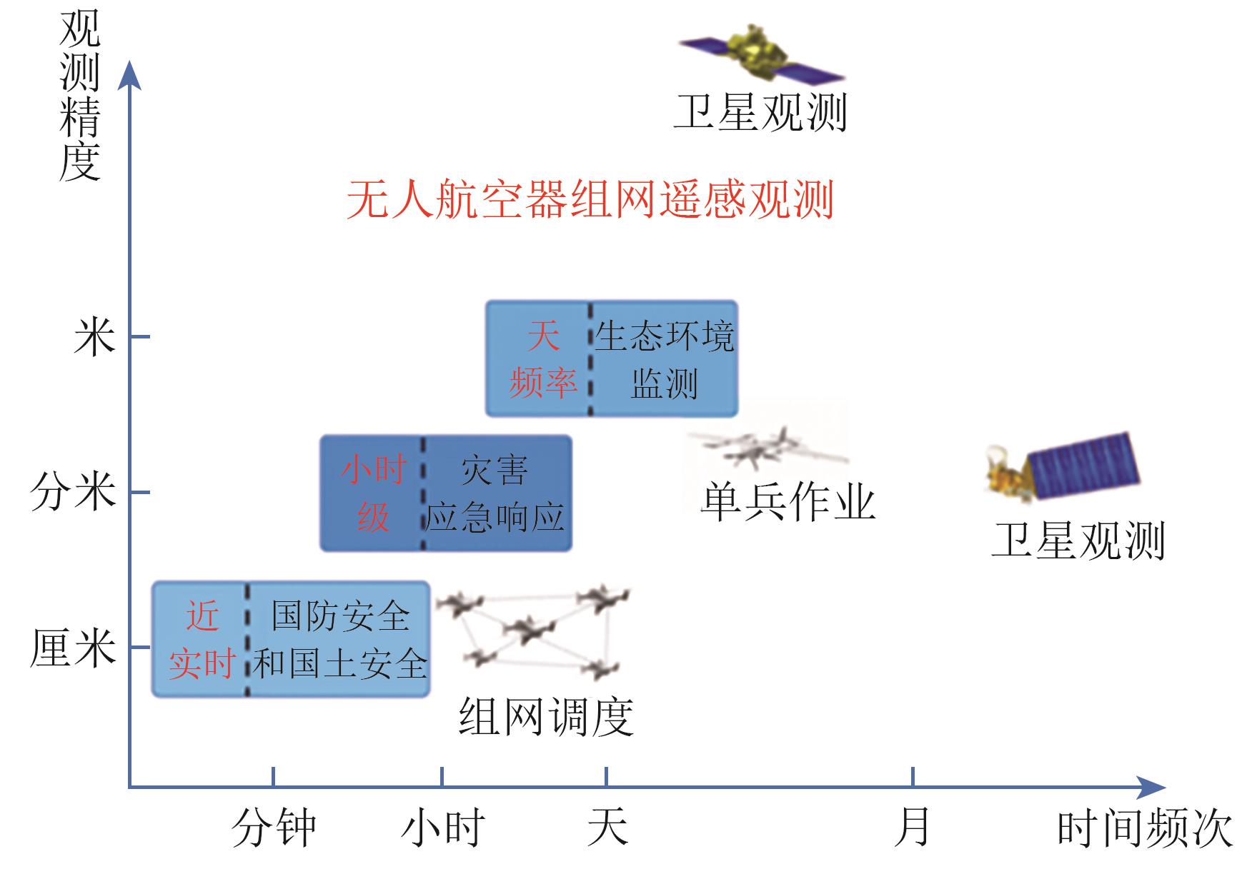 摘要:With continuous advancements in UAV platform technologies and payload capacities, UAV-based remote sensing has been widely adopted. It effectively compensates for the limitations of satellite remote sensing in terms of spatial resolution and revisit frequency. However, challenges remain in large-scale data coverage within short timeframes and in the fusion and processing of massive datasets. To address these issues, networked UAV remote sensing technologies have emerged. From China’s 13th Five-Year Plan to the current 14th Five-Year Plan period, innovations in UAV and remote sensing technologies have driven each other forward, with the technological frontier evolving from “High-Frequency and Rapid Response” to “All-Time and All-Area Coverage”.During and prior to the 13th Five-Year Plan period, on-site UAV networking remote sensing was primarily used in emergency search and rescue, disaster monitoring, and damage assessment. Regional UAV networking was widely applied in power grid inspection, mapping, ecological monitoring, and crop condition assessment. At that stage, the entire technical chain necessary for high-frequency and rapid-response UAV remote sensing was largely established, though there were still limitations in terms of intelligence and real-time capabilities. These limitations restricted the deployment of UAV networked remote sensing in complex geographic environments and time-sensitive scenarios.With ongoing technological progress and strong national policy support for developing the low-altitude economy, UAV networked remote sensing has naturally evolved in the 14th Five-Year Plan period toward all-time, all-domain, intelligent sensing. Autonomous and intelligent sensing has now become the latest research frontier in UAV-based remote sensing. This paper reviews the technological evolution and application trends of UAV networked remote sensing, and provides an analysis of key technologies, policies, and standards for its future development.关键词:UAV;networked UAV remote sensing;all-time and all-area coverage;air-ground coordination;low-altitude economy234|184|0更新时间:2025-09-01
 - “热红外遥感技术在自然资源调查等领域取得显著进展,为国民经济和社会服务做出重要贡献。”
 摘要:Thermal infrared (TIR) remote sensing is a branch of remote sensing that focuses on the acquisition, processing, and interpretation of data in the TIR region of the electromagnetic spectrum, ranging from 3 μm to 15 μm. This technology is critical for studying the thermal radiation characteristics of the Earth’s surface and its changes. Over the last 6 decades, remarkable achievements have been achieved in sensor development, theoretical understanding, and methodological approaches within TIR remote sensing. At present, more than 60 operational satellites are equipped with TIR sensors, thereby offering substantial improvements in spatial resolution, detection channels, and capabilities. For example, the thermal bands of the widely used Moderate Resolution Imaging Spectroradiometer (MODIS) provide a spatial resolution of 1 km; however, the recent HotSat-1, launched in June 2023, offers the highest-resolution commercial TIR sensor in orbit, capable of identifying features as small as 3.5 m. This progress marks a new era in Earth observation and climate monitoring. Moreover, hyperspectral TIR data offers unique insights into the Earth’s surface and atmosphere.Alongside sensor advancements, notable progress has been made in the retrieval of atmospheric and surface parameters. Various methods, such as the single-channel, split-window, temperature, and emissivity separation, as well as the day–night methods, have been developed to derive Land Surface Temperature (LST) accurately. LST is a critical parameter in the land–atmosphere energy balance. Advancements in TIR observation retrieval methods have driven the development of various LST products. At present, more than 30 types of LST products are publicly available, including those from Landsat, the Advanced Spaceborne Thermal Emission and Reflection Radiometer, MODIS, the Advanced Baseline Imager, and the Satellite Application Facility on Land Surface Analysis. The integration of physics-based models with data-driven Artificial Intelligence (AI), the “TIR + AI” paradigm, can considerably enhance the interpretation of TIR images and information extraction capabilities.These innovations have expanded TIR’s applications across diverse fields, including natural resource monitoring, ecological assessment, disaster response, planetary exploration, human health evaluation, and public safety. For example, security agencies typically rely on fingerprints and documentation to verify individuals’ identities. Moreover, current research indicates that analyzing skin temperatures with infrared cameras makes detecting fraudulent identities possible with an acceptable margin of error. Furthermore, TIR remote sensing is expected to play increasingly important roles in the exploration of deep space, thereby providing insights into planetary components, mineral exploration, space weather, and human habitation. Therefore, the benefits of TIR are significant and have contributed significantly to national economies and the societal well-being of individuals and populations.This study presents a comprehensive review of the state of the art in the field of TIR remote sensing by discussing the historical development of TIR sensors, the evolution of retrieval methods, and various applications. It also explores future trends and challenges, thereby highlighting opportunities for further innovation. In the coming years, several key technologies, namely, advanced sensor systems, AI integration with physical models, real-time remote sensing, and data fusion with optical and microwave sources, are expected to enhance the understanding and management of environmental, geological, anthropogenic, and disaster phenomena, thereby positioning TIR remote sensing as an indispensable tool for researchers, policymakers, and emergency responders.关键词:thermal infrared remote sensing;sensor;parameter retrieval;remote sensing application;development and challenges515|1157|0更新时间:2025-09-01
 - “在遥感领域,多模态对齐技术的发展为解决多模态数据融合问题提供了新途径,为对地观测任务带来新机遇。”
 摘要:In recent years, the advancement of sensor technology has significantly expanded the application of data from visible light, multispectral, infrared, and synthetic aperture radar sensors across various fields such as precision agriculture, military reconnaissance, and hydrological detection. Multimodal alignment in remote sensing has gained increasing attention, aiming to establish spatiotemporal or semantic relationships between different modal data, thereby achieving efficient data fusion and interoperability. Multimodal alignment is categorized into two main types: semantic and spatiotemporal alignments. Spatiotemporal alignment seeks to synchronize or associate data from different modalities in both time and space, while semantic alignment involves mapping different modal data into a shared high-level semantic space to ensure consistency at the semantic level.Firstly, this study explores the primary application needs of multimodal alignment technology in remote sensing. Key applications include multimodal image registration and fusion, vision-based UAV positioning, and target matching for spatiotemporal alignment, as well as multimodal fusion recognition, image retrieval, and remote sensing change detection for semantic alignment. These applications focus on the spatiotemporal alignment of multimodal remote sensing images to support subsequent image fusion and recognition, and on the semantic alignment of images and text to optimize multimodal information fusion in multi-sensor interactions. Additionally, the study compiles and organizes typical multimodal alignment datasets to support various applications, providing a solid foundation for further research and development in this area.Then,the study reviews the research status of multimodal alignment technology in remote sensing, noting a significant increase in attention over the past decade, particularly in semantic alignment research. It discusses multimodal spatiotemporal alignment from region-based, feature-based, and deep learning perspectives, highlighting the advantages and disadvantages of each method. It then examines semantic alignment through contrastive learning and generative models, including extensions to image-text-geographic coordinate alignment and addressing high-level issues like logical reasoning, hallucination, and the integration of external structured knowledge in generative models. The study summarizes typical multimodal alignment methods and their successful applications, demonstrating the progress and potential of these technologies.Furthermore, the study details the challenges encountered in real-world remote sensing applications of different multimodal alignment technologies. In spatiotemporal alignment, challenges include large image scale differences, modality specificity, temporal discrepancies, and high computational costs. In semantic alignment, challenges arise from semantic gaps between modalities, poor generality of foundational models, and data scarcity. These challenges underscore the need for continued innovation and refinement in alignment techniques to enhance their applicability and effectiveness in diverse scenarios.Finally, the study forecasts future development directions for multimodal alignment technology in remote sensing. These include researching resource-constrained multi-platform alignment mechanisms, developing foundational models specifically for the remote sensing domain, enriching multimodal alignment datasets, and integrating spatiotemporal with semantic alignment. The study predicts that advancements in these areas will drive innovative applications in environmental monitoring, resource investigation, and national defense security. By addressing current challenges and exploring new frontiers, multimodal alignment technology is poised to significantly impact the field of remote sensing, enabling more accurate, efficient, and comprehensive data analysis and interpretation. This will ultimately lead to enhanced decision-making capabilities and more effective solutions to complex real-world problems.关键词:multimodal alignment;spatiotemporal alignment;semantic alignment;remote sensing scenario438|1618|0更新时间:2025-09-01
 - “在遥感领域,多模态数据协同分析提升解译能力,图文跨模态理解显著提升遥感解译性能。”
 摘要:With the deep integration of remote sensing technology and artificial intelligence, the human demand for the application of remote sensing data has become increasingly refined. However, single-modal data has limitations in the interpretation of complex scenes. Optical imagery, while rich in spatial information, suffers from weather dependencies; Synthetic Aperture Radar (SAR) data provides all-weather capability but lacks intuitive interpretability; and hyperspectral data, despite its detailed spectral signatures, presents challenges in data redundancy and computational complexity. Therefore, single-modal data is difficult to fully exploit the deeper information in remote sensing images. These limitations underscore the critical need for more advanced analytical approaches that can overcome the constraints of single-modal data interpretation.For this reason, the collaborative analysis of multi-modal data has become a key way to enhance the interpretation capability of remote sensing and is driving the further development of the remote sensing field. By integrating complementary data sources and leveraging their synergistic relationships, multi-modal approaches enable more robust and comprehensive scene interpretation. Among various multi-modal strategies, remote sensing image-text cross-modal understanding has gained particular prominence as it establishes a vital connection between remote sensing image features and human semantic cognition. This framework enhances visual feature representations with the help of text semantic information and achieves cross-modal information complementarity, which significantly improves the performance of remote sensing interpretation. This paper provides a comprehensive examination of remote sensing image-text cross-modal understanding, which is categorized into four main types of tasks: remote sensing image captioning (referred to as image-to-text), text-to-image generation (referred to as text-to-image), remote sensing image-text alignment (referred to as image-text alignment), and remote sensing visual question answering (referred to as image-text dialogue). From the perspective of cross-modal transformation of images and text, remote sensing image-text cross-modal understanding includes image-to-text and text-to-image. In terms of local content interaction, remote sensing image-text cross-modal understanding includes image-text alignment and image-text dialogue.This paper begins with a thorough review of the historical development and current state of image-text cross-modal research. The research progress at home and abroad of four tasks, namely image-to-text, text-to-image, image-text alignment, and image-text dialogue, is reviewed. The key technological breakthroughs in the fields of image-text cross-modal are mainly introduced. On this basis, the in-depth analysis is conducted on the technical difficulties faced by the four tasks. Then, it presents a detailed analysis of commonly used public datasets and evaluation metrics for remote sensing image-text cross-modal understanding. Finally, it summarizes the technical challenges in this field, which mainly include three aspects: modal alignment of remote sensing images and text, cross-modal interpretability, and cross-modal reasoning. Based on the proposed problem of remote sensing image-text cross-modal, it looks forward to the future research directions. (1) In-depth mining of cross-modal information (2) Construction of earth science knowledge graph. (3) Human-computer interaction. (4) Large-scale remote sensing image-text model. (5) Language diversity. (6) Remote sensing multi-source data.This comprehensive investigation not only synthesizes current research but also provides a clear roadmap for future research in remote sensing image-text cross-modal understanding, with potential implications for numerous practical applications in environmental monitoring, urban planning, and disaster management.关键词:remote sensing image-text cross-modal;image captioning;text-to-image generation;image-text alignment;visual question answering;remote sensing cross-modal datasets231|365|0更新时间:2025-09-01
 - “在遥感影像智能解译领域,专家分析了双时相高分辨率遥感影像变化检测的典型算法和最新进展,为相关研究提供参考。”
 摘要:Bi-temporal remote sensing image change detection stands as a prevalent direction in the realm of intellectual interpretation and applied research of remote sensing imagery. It aims to acquire information regarding changes in land cover types or geophysical attributes within a monitored area over a specified time span, according to practical application requirements. Over the past few years, remote sensing image change detection techniques have undergone a rapid evolution and upgrading, fueled by the synergetic forces of the ever-growing remote sensing big data (especially the proliferation of very-high-resolution remote sensing images) and the revolutionary advancements in deep learning. In this paper, we delve into and analyze the existing popular algorithms for common change detection tasks using bi-temporal very-high-resolution remote sensing images, encompassing binary change detection that aims to identify the presence or absence of changes, semantic change detection that delves deeper into the semantic categories of the changed areas, building damage assessment that applies to natural disasters, and change captioning that focuses on generating meaningful descriptions of the detected changes using natural language. Finally, we present an outlook on the pivotal research trends in remote sensing image change detection and highlight lingering open issues under the current developmental trajectory, with the intention of offering some valuable insights and perspectives for future research endeavors in this field.Through this review, we raise two observations as follows. 1) Deep learning solutions for the common change detection tasks in remote sensing have been continuously evolving, with many innovative algorithms proposed; 2) The advanced capabilities of current vision and language foundation models have subtly permeated into this field. In fact, the remote sensing domain itself has witnessed a highly encouraging development trend of foundation models. On this basis, remote sensing change detection tends to embark on new development opportunities, and would face a reshaping of its technological landscape in the future.Though, researchers have to spend efforts in developing specialized solutions to (1) enhance the reliability of change detection in complex scenes. At present, even for the relatively mature fully supervised binary change detection, the detection results often show a complete loss of changed entities when faced with some complex scenarios. In semantic change detection, there may even be a phenomenon where the segmented changed semantics are not consistent with the binary change detection results. (2) reduce the dependence on bi-temporal image registration. This requires new algorithms to be developed to adaptively handle small misalignments and deformations in the spatial positions of corresponding objects in bi-temporal images and complete change detection in this case. (3) improve the practicality of multi-modal change detection. This may ask for a comprehensive framework that integrates multi-modal information extraction, feature registration and fusion, and change detection. Meanwhile, semi-supervised or weakly supervised learning methods are expected to become a research focus due to the annotation difficulty of heterogeneous remote sensing data. Besides, it is also believed that the synergy between image modality and language modality has broad prospects for future research in remote sensing change detection, owing to the increasing advancement of large language models as well as vision and remote sensing foundation models.关键词:very-high-resolution (VHR) remote sensing images;bi-temporal images;deep learning;change detection;literature review785|1780|0更新时间:2025-09-01
 - “在合成孔径雷达图像解译领域,融合电磁散射特征和神经网络特征的深度学习方法取得新进展,为提高目标识别精度提供新方案。”
 摘要:Automated interpretation of Synthetic Aperture Radar (SAR) images is one of the important development directions in the application of SAR technology, the core of which lies in how to efficiently extract target information from complex SAR images and realize automatic recognition. SAR target recognition methods are mainly classified into two main categories: traditional Machine Learning (ML) methods and Deep Learning (DL) methods. Traditional methods usually rely on hand-designed features extracted from Electromagnetic Scattering Features (ESF) that have clear physical meaning and high interpretability. For example, features such as the ESF, Radar Cross Section (RCS), and polarization characteristics of a target can directly reflect the target’s geometric structure, material properties, and its interaction mechanism with electromagnetic waves. These features show strong stability in target classification and identification tasks, especially in complex environments or under low Signal Noise Ratio (SNR) conditions. However, the limitations of traditional methods are that the feature extraction process is often complex and computationally inefficient, while relying on the a priori knowledge of domain experts, which makes it difficult to adapt to large-scale data processing and diverse target recognition needs.In contrast, DL methods are able to automatically extract high-dimensional features from SAR images through an end-to-end learning approach, avoiding the tedious process of manually designing features. DL methods usually outperform traditional methods in terms of target recognition accuracy, especially when dealing with SAR images with high resolution and complex backgrounds. However, DL methods also have obvious shortcomings, such as the poor interpretability of the model, which makes it difficult to explain its decision-making process; at the same time, the generalization performance of Neural Network Features (NNF) is often limited by the quality and diversity of the training data, and performance degradation may occur in the face of unseen targets or scenes.In order to overcome the limitations of traditional ML methods and DL methods, researchers in recent years have proposed a DL method that fuses ESF and NNF. This fusion method aims to combine the advantages of both. On the one hand, the physical interpretability and stability of electromagnetic scattering features are utilized to enhance the model’s understanding of the target’s intrinsic attributes. On the other hand, the high-dimensional features extracted by neural networks are used to enhance the model’s recognition accuracy and adaptability. For example, in the recognition task of targets such as vehicles, aircrafts and ships, the fusion method significantly improves the recognition accuracy by combining the ESF of the targets (e.g., strong scattering point distribution, polarization response) with the NNF, while improving the interpretability of the model to some extent.The paper discusses the research results of target recognition methods based on the fusion of ESF and NNF, details the application of this idea of fusing ESF for target recognition of vehicles, aircraft and ships, and looks forward to and summarizes the future development trends of target recognition and detection research.关键词:remote sensing;synthetic aperture radar (SAR);target recognition;Convolutional Neural Networks (CNN);Electromagnetic Scattering Features (ESF);parameter estimation265|615|0更新时间:2025-09-01
 - “在遥感领域,集成学习通过多学习器组合提升决策性能,专家总结了其在目标识别、地表覆盖分类等方面的研究进展,为遥感数据向地学知识转化提供新方向。”
 摘要:Ensemble learning, a machine learning paradigm rooted in the principle of collaborative complementarity, overcomes the limitations of individual learners by effectively combining multiple learners to enhance overall decision-making performance. In the field of remote sensing, ensemble learning has been widely adopted due to its ability to integrate multi-source data and leverage the strengths of diverse algorithms. Based on a systematic review of global research progress, this paper summarizes the key technological breakthroughs and applications of ensemble learning in remote sensing image processing and information extraction, and emphasizes the crucial role of its technological advantages in mining Earth’s big data. With the rapid advancement of remote sensing technologies and artificial intelligence, the demand for transforming remote sensing data into geoscientific knowledge is growing, driving ensemble learning toward deeper integration of data, algorithms, and knowledge. Remote sensing image processing and information extraction involve multi-source heterogeneous data, multidimensional features, diverse algorithms, and varied scenarios. Machine learning theory suggests that no single algorithm can achieve optimal performance across all scenarios and datasets. Consequently, ensemble learning has been introduced to remote sensing, demonstrating significant advantages in applications such as remote sensing target recognition, land cover classification, multi-temporal change detection and time series remote sensing data analysis, surface parameter inversion, ensemble of remote sensing and social sensing data, and mechanism and learning ensemble. Ensemble learning, by integrating multi-source data, heterogeneous models, and knowledge constraints, markedly improves the accuracy and generalization capability of remote sensing application. It is extensively applied in the production of global land cover products, forest disturbance monitoring, and data product development in environmental change domains such as hydrological cycles, providing robust support for the advancement of remote sensing applications in geoscience. In addition, the integration of remote sensing and social sensing data has expanded the boundaries of remote sensing applications, particularly in handling multi-source heterogeneous data. By incorporating physical mechanistic models, ensemble learning leverages physical constraints and nonlinear fitting capabilities, achieving notable improvements in model generalization, computational efficiency, and prediction accuracy. To address the pressing needs of Earth big data mining and geographic coupling studies, this paper proposes four future directions for ensemble learning in remote sensing: (1) integration of large-scale remote sensing models with interpretability, incorporating physical mechanisms, geographic processes, and domain knowledge to enhance model interpretability and address the shortcomings of deep learning; (2) diversity composition and measurement, utilizing multi-temporal, multi-spectral, multi-angular, and polarized remote sensing imagery to construct seamless data cubes and maximize the benefits of data, feature, model, and knowledge diversity; (3) novel ensemble strategies, leveraging self-learning and evolutionary learning frameworks combined with generative self-supervised models to innovate ensemble learning in deep learning contexts; and (4) optimized adaptation of ensemble models to geoscientific demands, particularly in sustainability studies like vulnerability analysis, where multi-source data and multi-model integration enable precise assessment and prediction of complex geographic and environmental factors. Ensemble learning is poised to become a cornerstone in developing geographic and remote sensing large models, particularly in harnessing the strengths of specialized small models and knowledge-constrained integration.关键词:remote sensing;ensemble learning;image classification;change detection;Mechanism and learning ensemble405|487|0更新时间:2025-09-01
 - “在遥感图像领域,专家构建了基于先验信息的高分高光谱图像计算成像统一模型,为突破光学遥感成像系统物理局限提供有效途径。”
 摘要:High-spatial-resolution hyperspectral remote sensed images can provide abundant spatial and spectral information at the same time, which is extremely important for practical applications such as precision agriculture, environmental monitoring, target detection and so on, and is one of the long-term goals in the field of remote sensing. Considering that the high-spatial resolution and high-spectral resolution are two imaging indexes mutually restricted from each other, it is still challenging to obtain the high-spatial-resolution hyperspectral images directly using the existing imaging technology, which limits its practical applicability. As one of the important technical means to reconstruct the high-spatial-resolution hyperspectral image, computational imaging can take the low-spatial-resolution hyperspectral image at the same time and over the same scene as a spectral priori, and fuse it with the spatial information provided by the high-spatial-resolution multispectral image based on the imaging model. It can also take the image-pair library or the spectral library as the priori information, and then reconstruct the high-spatial-resolution hyperspectral image by spectral super-resolution through spectral mapping. Here firstly, facing the above different ways of computational imaging for high-spatial-resolution hyperspectral images, a unified computational imaging model for high-spatial-resolution hyperspectral images based on prior information is constructed in this study. Then, according to the different sources of prior information, this paper summarizes the developing process and the related representative methods from the fusion of low-spatial-resolution hyperspectral and high-spatial-resolution multispectral images, to the image-pair learning based spectral super-resolution for high-spatial-resolution hyperspectral images, and to the latest spectral library learning based spectral super-resolution for high-spatial-resolution hyperspectral images. Besides, the basic ideas, advantages and limitations of the existing algorithms are systematically analyzed. And finally, three possible future trends including cross-domain adaptation, multi-library alignment, and hardware implementation are analyzed and discussed in the context of the future research direction of computational imaging for the high-spatial-resolution hyperspectral image. The results show that the computational imaging of high-spatial-resolution hyperspectral remote sensed images is one of the effective ways to break through the physical limitations of the remote sensed imaging system. Incorporating fusion and spectral super-resolution into a unified framework is conducive to systematically combing different sources of prior information, leading to more targeted high-precision and high-stability reconstruction. This study provides a unified framework and technical means for computational imaging of high-spatial-resolution hyperspectral remote sensed images, clarifies the future development direction of remote sensed image fusion and spectral super-resolution, and is expected to furtherly improve the ability of fine structure detection and fine spectral discrimination, thus providing technical support for the subsequent high-precision and high-reliability spectral target detection, object classification and other application tasks.关键词:remote sensing;high-spatial-resolution hyperspectral image;unified computational imaging model;high-spatial-resolution multispectral image;image-pair library;spectral library500|429|0更新时间:2025-09-01
 - “资源一号02E卫星热红外载荷采用双向加密采样技术,实现影像超分辨率重建,有效提高分辨率,为遥感领域提供新解决方案。”
 摘要:The advancement of Super-Resolution (SR) imaging in remote sensing holds significant potential for enhancing spatial resolution in applications. Since SPOT-5, researchers have been investigating a new super-resolution imaging mode based on “sub-pixel shifted sampling”. On this basis, researchers have further proposed the concept of “bidirectional overlapping sub-pixel shifted sampling”. Similar to the SPOT-5 mode, it acquires 2 frames shifted by only 0.5 pixels in the along-track direction and then 0.5 pixels in the vertical direction additionally, i.e., it can acquire 4 frames with half-pixel relative shifts. The thermal infrared camera of ZY-1 02E satellite is the first remote sensor in China that supports image super-resolution by means of “bidirectional overlapping sub-pixel shifted sampling”. This paper describes in detail the principle of bidirectional overlapping sub-pixel shifted sampling of the thermal infrared camera of ZY-1 02E. However, since common super-resolution algorithms are not compatible with the special imaging mode, it is necessary to put forward a super-resolution method that is specifically suitable for the “sub-pixel shifted sampling” mode. Based on the hardware features of bidirectional overlapping sub-pixel shifted sampling, an observation equation model and maximum a posteriori probability (MAP) method are introduced to realize image super-resolution in this paper. In order to obtain a higher resolution image from 4-frame “bidirectional overlapping sub-pixel shifted sampled” original images, it is necessary to go through two steps: multi-frame overlapping up-sampling and multi-frame sequential super-resolution reconstruction. For the multi-frame overlapping up-sampling step, this paper proposes an observation equation model to describe the fixed half-pixel shifted relationship between frames, which can effectively utilize the complementary information between frames and significantly suppress the noise. Then the result of the first step is used as the estimated initial value, and a improved MAP method is proposed for sequence super-resolution reconstruction. In this paper, we use the real thermal infrared overlapping sampling mode data of ZY-1 02E to validate and analyze super-resolution, and the experiments show that the hardware mode of bidirectional encrypted sampling can effectively improve the resolution compared with the conventional imaging mode. Judging from the visual effect, the result images of this paper’s algorithm are clear in detail and the noise is not significantly enlarged. In order to quantitatively evaluate the super-resolution results, three unsupervised metrics, average gradient, entropy, and signal-to-noise ratio, are used. By visually and quantitatively comparison, this paper’s algorithm outperforms the method considering only hardware characteristics and the conventional MAP method considering only software algorithms, respectively. The method proposed in this paper achieves the maximum average gradient and entropy due to the integration of the observation equation and the principle of maximum a posteriori probability, while the signal-to-noise ratio remains high, indicating that this method effectively enhances the high-frequency detail information of the image while the noise is not significantly increased. The method in this paper effectively solves the super-resolution problem of ZY-1 02E thermal infrared bidirectional sub-pixel shifted sampling mode.关键词:thermal infrared remote sensing;ZY-1 02E satellite;super resolution;bidirectional overlapping sampling;sub-pixel shifted134|263|0更新时间:2025-09-01
 - “在遥感领域,专家梳理了3类数据驱动方法,通过遥感图像时间序列建模,验证了其有效性,为地表动态变化过程建模提供新方向。”
 摘要:Land surface dynamic is one of the key research objects in the field of remote sensing, and the systematic mastery of the law of land surface evolution over time is a long-term and arduous task in the research of earth observation, which has a far-reaching impact in many fields such as natural resources, ecological environment, disaster prevention and mitigation, etc. However, due to the complexity of the driving factors and their effecting mechanisms of land surface changes, most of the modeling of land surface dynamics is simplified or localized, and it is difficult to form a complete physical model with its corresponding mathematical formula expression.From a methodological point of view, along with the rapid development of big data and AI for Science techniques in recent years, a class of data-driven modeling methods for dynamic systems have emerged in addition to physical modeling. Directly using the observed data series as input, data-driven methods can construct models that fit the data well enough to approximate or even replace underlying physical models. In this paper, we introduce three types of data-driven approaches for modeling land surface dynamics, namely, the temporal-spatial mode decomposition, the governing partial differential equation identification, and the state variable discovery network.Temporal-spatial mode decomposition method extracts base modes in the data that represent the basic characteristics of the system state, which helps us to understand the intrinsic properties of the system and further predict the future state of the system in combination with parametric prediction methods. This method is able to separate the temporal and spatial variations of the flow field, decompose the time-varying flow field into the sum of the products of the spatial function that does not vary with time and the temporal function that only relies on the time variations, thus objectively and quantitatively reflecting the flow field's spatial structure and temporal variations of the flow field.Governing partial differential equation identification method assumes that the dynamical system expressed by the differential equations is variably complex and nonlinear and needs to be characterized by nonlinear functions. Thus, it constructs a library of functions covering a wide range of potential nonlinear terms, where the functions and partial derivatives in the library are likely to appear in the unknown governing equation, and the equation is assumed to be a linear regression of these candidate functions. This method does not rely on a priori knowledge but learns the dynamics of the system directly from the observed data.State variable discovery network method discovers the dynamics of physical systems directly from sequential data through a network of self-encoders, which centers on the discovery of hidden state variables from high-dimensional observational data, which can then be used to make predictions about the future state of the system. The state variable of a system refers to the smallest set of variables that are sufficient to completely determine the state of motion of the system.The three types of methods are used to construct dynamic system models from remote sensing time series and the accuracy of modeling is evaluated by image time series prediction. The experimental results preliminarily validate the effectiveness of the data-driven modeling methods and show the characteristics, research value and application prospects of each of the three types of methods.关键词:land surface dynamics;time series;process modeling;mode decomposition;partial differential equation;autoencoder;data driven;sparse regression211|919|0更新时间:2025-09-01
 - “遥感技术发展迅速,高光谱图像成关键数据源。深度学习模式识别算法不断突破,图神经网络在高光谱遥感图像解译中广泛应用,挖掘样本间关系,生成高精度分类结果。专家从图连接、图节点、网络模型角度分析图神经网络方法,为遥感领域研究提供方向和思路。”
 摘要:The rapid development of remote sensing technology has brought a variety of remote sensing data. Hyperspectral images, with the highest spectral resolution among these data, are always a crucial source for various Earth observation applications. In the field of computer vision, pattern recognition algorithms represented by deep learning also constantly developing and breaking through the limitations, providing more effective technologies for hyperspectral remote sensing applications. In recent years, Graph Neural Networks (GNNs) have been widely utilized in hyperspectral remote sensing image interpretation tasks, which can leverage the underlying relationships between samples to extract both local and global contextual information, producing high-precision classification results even with a limited number of labeled samples. This paper summarizes the most commonly used GNN frameworks from existing studies, analyzing the characteristics of these methods by decomposing their structures and categorizing them. We first extract the commonalities of existing GNN architectures and propose a basic module of GNN, which consists of an information aggregation function and a feature updating function. Building upon this module, we reinterpret various popular GNN architectures, including spectral-based Graph Convolutional Networks (GCNs), spatial-based GCNs, and Graph Autoencoders (GAEs). In the context of GAEs, current approaches are analyzed from three perspectives: loss functions, decoders, and graph reconstruction methods. These methods formulate loss functions to incorporate various graph-based constraints, thereby embodying the implicit assumptions and specific characteristics inherent to each method. Then, the analyses of GNN methods in the remote sensing field are conducted from three perspectives: graph connections, graph nodes, and network models. The existing research outcomes are classified based on the spatial range of connections, the information hierarchy of nodes, and the uncertainty of models. These GNN-based algorithms extract either local information or non-local information (e.g., global or local-global interactions) by using graph connections across different spatial ranges. The concept of non-local modeling has been extensively explored in GNNs over the past four years. Among GNNs with different node information hierarchies, approaches of using superpixels as graph node representations are the most prevalent. This is because superpixels can serve as a generalized form of node representation for other hierarchies, and their construction is relatively straightforward. Additionally, this paper introduces the application of GNNs in hyperspectral remote sensing image classification under varying modal and label quantities. For single-modal applications, we summarize the characteristics of several representative algorithms and provide their corresponding code implementations. For a limited number of multi-modal applications, we categorize and introduce methods based on the role of GNNs in multi-modal feature fusion. We conduct detailed analyses of the performance of GNN-based classification models in relevant literature, evaluating the applicability of these methods by considering the number of labeled samples and their corresponding classification accuracies. Furthermore, we elaborate on the theoretical foundations and integrated techniques of these models in the fields of supervised, semi-supervised, and unsupervised classification. Finally, the paper summarizes and looks forward to the frontier technologies of GNNs from three aspects: deep graph networks, GNN integrated with other deep learning techniques, and GNN-based foundation models, providing directions and insights for future research in the remote sensing field.关键词:hyperspectral remote sensing;classification;graph neural network;graph convolutional networks;deep learning524|958|0更新时间:2025-09-01
 - “空天信息智能解译领域取得新进展,专家建立了因果智能认知体系,为解决空天信息解译问题提供新方案。”
 摘要:Aerospace information intelligent interpretation refers to the utilization of artificial intelligence technology to intelligently process multi-source remote sensing data acquired from space-based platforms such as satellites and space stations, or from unmanned aerial vehicles and floatation vehicles, in order to extract key information from them and to realize highly efficient and automated analysis as well as application. With the rapid advancement of deep learning, data-driven intelligent interpretation models have become the mainstream approach. These models leverage large-scale, high-quality annotated datasets and sophisticated neural network architectures to enhance interpretation performance. However, despite their success, such methods still face several challenges in practical applications. For instance, they heavily rely on extensive annotated datasets, leading to high data acquisition and manual labeling costs. Additionally, these models often exhibit limited generalization capabilities, making them less adaptable to diverse remote sensing environments and varying data distributions. Furthermore, traditional deep learning models typically lack interpretability, as their feature-fitting processes based on statistical correlations are susceptible to confounding factors, reducing reliability and trustworthiness in real-world decision-making. To address these challenges, causality-inspired intelligent interpretation methods integrate causal reasoning with deep learning, incorporating causal relationship modeling into data analysis. Unlike conventional data-driven methods, causality-inspired intelligent interpretation emphasizes not only statistical correlations among variables but also the modeling of causal relationships. This enables more rational inference and decision-making in complex aerospace data environments, thereby improving both interpretability and reliability. Consequently, causality-inspired intelligent interpretation is considered to be an essential development direction for aerospace information intelligent interpretation in the future, and it is promising to become a new interpretation paradigm. This review focuses on integrating causal theory into aerospace information interpretation models. First, it explores current trends and research directions in aerospace information interpretation from three perspectives: correlation analysis, statistical modeling, and causal cognition. Based on the principles of causality—association, intervention, and counterfactual reasoning—this review constructs a “ladder of causation” framework to illustrate the role of causal reasoning in aerospace information analysis. Next, the study examines causal discovery and causal effect estimation methods tailored to the spatiotemporal characteristics of aerospace data. It also investigates causal representation learning in deep neural networks to assess how causal reasoning can enhance the accuracy and robustness of intelligent interpretation. Subsequently, three primary approaches to constructing causality-inspired intelligent interpretation models are discussed: (1) interpretation based on causal graphical models, (2) interpretation using counterfactual reasoning, and (3) interpretation centered on feature-level causal interventions. By embedding causal relationships into intelligent interpretation models, these methods improve model generalization and explainability, offering scientifically grounded solutions for aerospace data analysis. Finally, this review introduces typical applications of causality-inspired intelligent interpretation in aerospace observation environments, and summarizes the ideas of combining causal reasoning with spatiotemporal data from earth observation, causal model with intelligent interpretation model, aiming to provide valuable insights and references for future research in this field.关键词:causal inference;intelligent interpretation;deep learning;causality-inspired;aerospace information;counterfactual inference;causal intervention247|1082|0更新时间:2025-09-01
 - “在月球探测领域,系统梳理了遥感制图精度相关概念,分析了误差来源和产品精度,提出了提高精度的途径。”
 摘要:The geometric accuracy of remote sensing mapping products is a crucial indicator for lunar exploration engineering applications and scientific research. This paper systematically investigates the fundamental concepts, methodologies, error sources, and product accuracies associated with lunar remote sensing mapping, while proposing strategies to enhance future mapping accuracies. The concepts of precision (internal consistency of measurements) and accuracy (closeness to true values) are clarified, emphasizing their distinct roles in lunar mapping. Due to the lack of absolute reference data (“ground truth”) on the Moon, precision often dominates discussions. Resolution is usually further differentiated into spatial resolution (sensor capability) and Ground Sample Distance (GSD, user-defined grid spacing).Photogrammetry and laser altimetry are the major technologies in lunar mapping. In stereo photogrammetry, which is widely used in lunar missions to reconstruct 3D topography from stereo images, the mapping accuracy depends on factors such as image matching precision, camera calibration errors, and orbit/attitude determination accuracy. Theoretical analyses show that elevation error is inversely proportional to the base-to-height ratio and directly linked to GSD and pixel measurement errors. For example, a base-to-heigh of 0.55 (31° convergence angle) yields a relative elevation error of 0.6 pixels. Absolute accuracy, however, is heavily influenced by orbit determination errors; a 0.01° attitude error at 50 km altitude introduces ~8.7 m positional deviation. Laser altimeters measure surface elevation by timing laser pulse returns. Key error sources include instrument limitations (e.g., pulse width, footprint size), terrain roughness, and orbit/attitude uncertainties. Orbit error propagates linearly to elevation results, whereas attitude-induced errors exhibit nonlinear behavior. Attitude errors in pitch and roll significantly affect elevation calculations, while yaw primarily impacts planar positioning.Photoclinometry (i.e., Shape-from-Shading, SfS) and AI-based mapping are emerging techniques for lunar mapping. SfS leverages radiance-topography relationships governed by Bidirectional Reflectance Distribution Functions (BRDF). While SfS achieves pixel-scale resolution from single images, it is sensitive to albedo variations and requires a low-resolution Digital Elevation Model (DEM) for absolute elevation referencing. AI-based mapping employs deep learning (e.g., CNNs, GANs) to predict DEMs from monocular images. Though efficient, these methods face challenges in generalizability, overfitting, and dependency on training data quality.Global Digital Orthophoto Maps (DOMs), such as those from Clementine (100 m/pixel) and LROC WAC (100 m/pixel), exhibit planar accuracies ranging from 100 m to sub-kilometer levels. China’s Chang’e-2 mission produced global DOM with 7 m/pixel resolution and planar accuracies of 21-97 m (validated via laser retroreflectors). High-resolution regional products, like LROC NAC mosaics (1—2 m/pixel), achieve sub-pixel precision and ~20 m absolute accuracy.Commonly used global lunar DEMs include LOLA DEM, SELENE DEM, Chang’e-2 DEM, among others. LOLA DEM, with resolutions of 256/512/1024 ppd, has 1 m vertical accuracy and ~20 m planar accuracy. SELENE DEM, derived from stereo images and validated via laser retroreflectors, has accuracies of 3—5 m in elevation, -17 m to 5 m for longitude, and -20 m to 48 m for latitude. Chang’e-2 DEM, validated via laser retroreflectors, has 21—97 m vertical accuracy and 2—19 m planar accuracy. The SLDEM2015, which is a merged product of LOLA and SELENE DEM and covers latitudes within ±60° at a resolution of 512 ppd (~60 m at the equator), has a typical vertical accuracy of ~3 to 4 m. Recently, a local improved LOLA DEM covering south polar region of 87.5°—90° at 5 m/pixel resolution has been generated through self-registration with a typical RMS elevation error of 0.30—0.50 m.Based on the reviews and analyses, the paper proposes approaches to improving the accuracy of lunar remote sensing mapping products in the future, including methods such as improving orbit and attitude determination accuracy, increasing control information, upgrading sensor capabilities, and innovating data processing techniques.关键词:lunar exploration;remote sensing mapping;geometric accuracy;digital elevation model;digital orthophoto map199|652|0更新时间:2025-09-01
 - “在定量遥感领域,专家深入分析真实性检验技术发展,为提升遥感观测能力提供新思路。”
 摘要:Validation, inversion, and scale problems have been listed as the three major scientific problems in quantitative remote sensing. Validation serves as a crucial foundation for reflecting and revealing the errors in remote sensing algorithms and products. It is also an important guarantee for the continuous improvement of remote sensing product quality. After nearly 40 years of development, validation has received widespread attention in the international remote sensing community. Thus far, the theory and methods of validation have become relatively mature, and an increasing number of practical validation works have been conducted. This scenario has played a wide role in clarifying the error distribution of remote sensing products, thereby iteratively improving the quality of remote sensing products and promoting the application benefits of remote sensing products. However, given the development of remote sensing science and technology, the connotation of validation should not be limited to assessing the accuracy of remote sensing products. The in-depth expansion of various macro and micro applications related to geography objectively promotes the proactive and systematic global analysis of various uncertainties in the entire process of remote sensing information from data acquisition to application from the perspective of remote sensing science and technology disciplines. As a result, the technological conditions and advantages of the era are linked, and the iterative space observation capabilities are improved. With 40 years of academic accumulation, particularly the development of remote sensing product validation technology, the theory, method, and technology of validation have evolved into a comprehensive system from traditional comparative analysis based on statistics to simulation validation grounded in physical models. At present, we have the validation capability for the whole chain of remote sensing, including quantitative remote sensing mechanism model validation, satellite imaging data calibration, remote sensing data product assessment, application effect evaluation, and even remote sensing observation theory and methods. However, remote sensing information has multidimensional characteristics of time, space, spectrum, and events. In previous research, validation techniques and methods were developed for various stages, including primary data product processing, model/algorithm evaluation, production, and application. However, these stages were merely linked through simplistic, rigid input-output relationships. The correlations and inheritance of uncertainties across these stages were not explored. This rigid model overlooked the intrinsic connections and mutual influences among various stages. Thus, validation was often limited to individual stages rather than addressing problems systematically as a whole. Merely “evaluating” the accuracy and uncertainty of remote sensing products is far from sufficient because the ultimate goal of validation is to enhance further the quality of remote sensing products. Systematically reorganizing the connotation, methodology, and output of validation, as well as forming a working mechanism for interdisciplinary cooperation within and across disciplines, is necessary to enhance remote sensing spatial observation capabilities systematically through validation. This study provides a new interpretation of the concept and connotation of validation, analyzes and summarizes the current status of methods and technological development, and examines the key challenges that urgently need to be overcome in validation at present. Finally, this study provides a view of the specific ideas and development prospects of validation in the future.关键词:remote sensing;global validation;pixel scale reference;uncertainty;error traceability203|276|0更新时间:2025-09-01
Technologies and Methodologies
- “遥感时谱理论揭示地表物体变化特征,应用于多领域,专家展望未来研究方向。”
 摘要:Long term remote sensing data contains information from four dimensions: time, space, and spectrum. Currently, the description is only based on spatial and spectral dimensions, and there is no unified concept to describe long-term remote sensing data. In traditional research, using a three-dimensional cube model to store long-term remote sensing data would separately store data from different time periods, which cannot meet the efficient storage, fast retrieval, and deep analysis of its time dimension, and thus cannot fully explore the characteristics of different land features changing over time. Essentially, it is still discrete three-dimensional data, and the four-dimensional information of long-term data has not been effectively managed and analyzed uniformly. Therefore, based on the research foundation of predecessors, the concept of time spectrum has emerged, bringing new breakthroughs to the organization and storage of remote sensing data, and improving the utilization value of long-term remote sensing data. Similar to the concept of spectra, remote sensing feature sequences at different times constitute spectrograms.Remote sensing spectrogram theory mainly describes the information of remote sensing data in spectral, temporal, and spatial dimensions. By analyzing the temporal spectrum of remote sensing images, the changing characteristics of surface objects at different time scales and spectral ranges can be revealed, which can be used in various application fields. Experts and scholars in the remote sensing field have fully recognized the scientific value and broad application prospects of MDD.Land change detection and fine classification of crops require the use of multiple spectral information from different time periods. Unlike traditional 3D datasets, the study of remote sensing data has been elevated from 3D to 4D, providing a different way for land features to be represented. This helps to solve the problem of “same spectrum foreign objects, same object different spectrum”. The analysis of cultivated land types based on spatiotemporal spectra also has the characteristics of complete phenology. It can effectively eliminate false changes caused by seasonal factors. The MDD format has significantly improved the efficiency and accuracy of remote sensing analysis, and has been widely promoted and applied in multiple industry user units, generating good social and economic benefits.This article summarizes and generalizes the basic concepts, main methods, and techniques of remote sensing spectrogram theory, introduces the application fields and latest research progress of remote sensing spectrogram theory, and finally looks forward to the future research directions of spectrogram theory. The future research directions in this field include the study of spatiotemporal consistency and data fusion of multi-source data, the research of deep learning time-frequency analysis methods, and the research of real-time and high-resolution analysis.In the field of next-generation remote sensing data storage, the multidimensional data format developed by Chinese scientists is expected to meet the needs of real-time online data processing, be used to develop a new spatiotemporal spectral integrated data organization and storage mode, and serve as one of the technical foundations of remote sensing cloud platforms. This innovation can improve the storage, retrieval, and sharing efficiency of remote sensing big data, providing key support for China to build an independent and controllable remote sensing cloud platform.关键词:remote sensing;multi-dimensional dataset;spectrotemporal dataset;spectrotemporal characteristics;spectrotemporal applications351|447|0更新时间:2025-09-01
 - “最新研究系统梳理了红树林定量遥感的研究进展,为红树林保护、恢复与可持续管理提供科学、可靠的理论与方法基础。”
 摘要:Mangroves are one of the most productive ecosystems globally, playing a crucial role in carbon sequestration and climate change mitigation. With the increasing awareness of mangrove conservation both domestically and internationally, as well as the rapid development of remote sensing sensors and artificial intelligence technologies, significant progress has been made in the field of mangrove remote sensing research. Literature retrieval shows that only 18.7% of SCI papers focus on the quantitative remote sensing of mangroves, and there is a lack of systematic reviews in this field. Quantitative remote sensing of mangroves refers to the use of electromagnetic wave information obtained by remote sensing sensors to quantitatively retrieve or estimate parameters related to mangrove biophysics (such as biomass, canopy height, Leaf Area Index (LAI), etc.), biochemistry (such as chlorophyll, nitrogen content, etc.), and ecological functions (such as gross/primary productivity, biodiversity, etc.), with the support of prior knowledge and computer systems, through mathematical or physical models. This study systematically reviews the research progress and future prospects of mangrove quantitative remote sensing through bibliometric analysis and literature review, providing insights for related fields of research. The results show that:(1) Compared to the period 1996—2012, the period from 2013—2024 has witnessed an explosive increase in research on various parameters, with the types of parameters gradually diversifying. Research has expanded from traditional biophysical parameters to include biochemical parameters such as nutrient elements and equivalent water thickness, as well as ecological function parameters like productivity, phenology, photosynthesis, and biodiversity. Among these studies, above-ground biomass (or carbon storage) is the most studied parameter, followed by tree height, LAI, chlorophyll content, and nutrient element content.(2) Remote sensing data sources have diversified, and researchers are increasingly focusing on the comparative analysis of the performance of different remote sensing sensors and the coupled application of multi-source remote sensing data, which has improved the inversion accuracy of various parameters.(3) Inversion models are primarily based on machine learning models, with random forest (RF) and XGBoost being the mainstream methods in current mangrove quantitative remote sensing inversion studies. However, there is insufficient research on physical models.(4) Quantitative remote sensing of mangroves is mainly focused on the landscape scale. In recent years, the spatial scope of research has gradually expanded to a global scale and a single tree scale, providing important data at different levels for mangrove health assessment and carbon cycle research.(5) The application of mangrove quantitative remote sensing in health status, disaster assessment, and ecological restoration management is receiving increasing attention.Future research should focus on strengthening the development of quantitative remote sensing products for mangrove biochemical and ecological function parameters at the national/global scale and constructing a cross-scale (canopy layer, understory vegetation, roots, and soil) 3D remote sensing monitoring system for mangroves. Specifically, this can be achieved by integrating hyperspectral satellite data with Sentinel series satellite imagery, combined with Deep Learning (DL) models and physical models, to further enhance the quantitative retrieval capabilities for mangrove ecosystems. Promoting the integration of various remote sensing technologies, including Unmanned Aerial Vehicle (UAV) remote sensing (such as chlorophyll fluorescence, thermal infrared, LiDAR, hyperspectral, etc.), high-resolution satellite imagery, and ground-based LiDAR data, will facilitate the construction of a multi-scale, multi-dimensional 3D remote sensing monitoring system, spanning from single-tree scale to species and landscape scales through data fusion. In addition, future research should focus on the deep integration of mangrove ecosystem process models and artificial intelligence models, aiming to reveal the underlying mechanisms and dynamic patterns of key ecological processes such as mangrove growth, carbon sequestration, and nutrient cycling. This will provide a more scientific and reliable theoretical and methodological foundation for the protection, restoration, and sustainable management of mangroves, thereby contributing to addressing urgent environmental challenges such as global climate change.关键词:quantitative remote sensing;mangrove;UAV;Satellite image;biophysical parameter;biochemical parameter;bibliometric347|646|0更新时间:2025-09-01
 - “最新研究揭示了人工智能在气溶胶遥感领域的重大变革,机器学习算法显著提升反演效率,为解决地气解耦合等问题提供新思路。”
 摘要:Atmospheric aerosols play a crucial role in the atmospheric environment, impacting climate change and human health, gathering significant attention over the last fifty years. With the continuous development of satellite remote sensing technologies, satellite-based aerosol observation has become one of the most important and effective means of acquiring large-scale, long-term aerosol data. The advancement of satellite sensor technologies has also played a critical role in enabling highly accurate aerosol retrieval. Moreover, with the successful launch of POLDER (Polarization and Directionality of the Earth’s Reflectances), multi-angle joint polarization observation has become a key development direction for atmospheric aerosol monitoring. China has made significant progress in satellite-borne polarimeters, including DPC (Directional Polarimetric Camera) on GF-5 in 2018, SMAC (Synchronization Monitoring Atmospheric Corrector) on GFDM in 2020, PSAC (Polarized Scanning Atmospheric Corrector) on HJ-2A/B in 2020, and the PCF (Polarization Crossfire Payload) on GF-5(02) in 2021. Subsequently, China launched a series of atmospheric environment monitoring satellites equipped with PCF suits. Internationally, NASA launched the PACE satellite in 2024, equipped with SPEXone and HARP2 polarimeters. A review of the development of satellite remote sensing for atmospheric aerosols reveals that early observation methods were limited. Constrained by computational capacity and the few satellite data, early retrieval algorithms primarily relied on lookup table (LUT) approaches to strike a balance between retrieval accuracy and algorithmic feasibility. With advancements in satellite observation technologies, aerosol retrieval algorithms have continued to evolve. In the current era of massive satellite datasets, a central challenge in aerosol remote sensing is how to effectively extract meaningful atmospheric information from these vast data resources. Over the past decade, statistically optimized algorithms have emerged as one of the most promising solutions. These physically based inversion methods aim to retrieve aerosol parameters by fitting satellite observations with forward radiative transfer simulations. However, the high computational cost of optimization algorithms poses a significant barrier to the real-time generation of satellite aerosol products on a large scale, highlighting the urgent need for innovative technological breakthroughs.Recently, the evolution of Artificial Intelligence (AI) has introduced transformative changes to aerosol remote sensing. Machine Learning (ML) techniques have shown notable enhancements in retrieval efficiency and the capability to tackle persistent issues that traditional physical methods face, such as separating signals from the surface and atmosphere. ML technologies are propelling satellite aerosol retrieval into an era of intelligent development. This paper presents a comprehensive review of the latest advancements in satellite-based aerosol retrieval algorithms using ML methods. It evaluates the strengths and limitations of mainstream ML techniques in different retrieval contexts. Overall, ML methods show great potential in aerosol remote sensing but still face limitations. It cannot yet fully replace physical models, but it offers promising prospects. Current research focuses on improving retrieval accuracy and efficiency for aerosol optical properties, while retrieval of microphysical and chemical properties remains exploratory. For near-surface Particulate Matter (PM) concentrations, ML methods can build statistical models supported by meteorological data, yet underlying physical mechanisms need refinement. Integrating ML with physical models is a key future direction to enhance the accuracy and robustness of aerosol retrieval. This review aims to offer useful insights for researchers and developers working on next-generation aerosol retrieval systems.关键词:aerosol;atmospheric remote sensing;machine learning;artificial intelligence;retrieval algorithms225|144|0更新时间:2025-09-01
 - “在人工智能和遥感技术融合的背景下,林草遥感技术在地类识别、变化检测等领域取得显著进展,为国家生态文明建设提供重要支撑。专家构建天空地一体化监测技术体系,推动林草遥感技术全面业务化应用。”摘要:The past five years are the five years when big model and general model of Artificial Intelligence (AI) are gradually integrated into people’s daily work and life, and the five years when remote sensing + AI technology develops rapidly in the fields of land cover type identification, change detection, etc. It is also the first five-year for the implementation of the national strategy of “ecological civilization” and “beautiful China”. Summarizing the progress made in the research, development and application of forestry and grassland remote sensing technology in these five years is of great significance for the country to formulate the development plan of forestry and grassland remote sensing in the future.The paper summarizes the main progress of the forestry and grassland remote sensing research and development in China in the past five years into four research directions, namely, change detection and classification of forest and grassland cover types, quantitative inversion/estimation of forest parameters by remote sensing, and that of grassland vegetation and early warning and monitoring of forest and grassland disasters. From a general point of view, the research on forestry and grassland remote sensing technology shows a rapid development trend from traditional shallow machine learning to deep learning, and from “data”-driven to “data + mechanism”-double-driven direction, and the deep learning method develops quickly and deeply in change detection and classification, but not in quantitative parameter inversion/estimation. The production technology of large-scale forest and grassland thematic products, such as global and national products, has also been developed rapidly.An analysis of the integration of remote sensing technology into existing technical standards and technical programs for forestry and grassland resources and ecological monitoring, disaster early warning monitoring and monitoring of nature reserves shows that forest and grassland cover type change detection/monitoring and classification technologies have been widely and deeply applied to various resource supervision and disaster early warning and monitoring operations in the forestry and grassland industry, but the degree of operational application of quantitative inversion/estimation technologies of forest and grassland quality parameter is still very low.In view of the challenges in promoting the comprehensive and in-depth application of forestry and grassland remote sensing technology, it is suggested that the forestry and grassland industry should vigorously integrate the “space-air-ground” multi-source earth observation resources, comprehensively apply remote sensing, artificial intelligence (AI), statistical inference and other cutting-edge technologies to build a “space-air-ground” integrated monitoring technology system, and greatly strengthen the investment in scientific research, technology exchange and talent exchange and cultivation.关键词:forestry and grassland;remote sensing technology;operational application;progress;countermeasures298|968|0更新时间:2025-09-01
- “中国冰冻圈遥感研究取得新进展,专家提出3项重点行动倡议,为气候应对与适应等提供支持。”
 摘要:This paper summarizes the major developments in cryosphere remote sensing research in China in recent years. With advancements in domestic remote sensing technology and the deepening of international cooperation, the breadth and depth of China’s cryosphere remote sensing research have continuously expanded. In terms of study areas, the focus has gradually extended from China (particularly the Qinghai-Tibet Plateau) to the Arctic, Antarctic regions and the global cryospheric regions. Regarding remote sensing data applications, reliance on foreign satellite data has transitioned into the joint use of both domestic (e.g., Gaofen, Fengyun satellites) and foreign remote sensing data. In algorithm development, traditional approaches—previously reliant on single data sources with limited automation—have evolved into advanced methodologies featuring multi-source data fusion and intelligent processing. The continuous emergence of various cryosphere remote sensing products has significantly contributed to monitoring and understanding global cryospheric changes. This paper also explores key frontier issues and potential breakthroughs in cryosphere remote sensing, including penetration capabilities, the development of intelligent algorithms, the detection of critical transitions, and advancements in cryosphere data products. Specifically, we discuss the progress and challenges of sensors such as ice-penetrating radar, glacier tomography radar, and active-passive microwave instruments for freeze–thaw cycle detection. It also outlines key directions for advancing intelligent algorithms, including label-free intelligent recognition of cryospheric targets, dual-driven simulations of cryospheric changes that integrate physical mechanisms and data, and autonomous AI-based analysis of cryospheric processes. Furthermore, the paper highlights the critical role of remote sensing in capturing cryospheric critical transitions from both spatial and temporal perspectives and proposes pathways for improving cryosphere data products and services. To further advance cryosphere remote sensing science, this paper proposes three key action initiatives for the near future. First, conducting a comprehensive tomographic remote sensing experiment focused on key cryospheric elements, including glaciers, snow cover, and shallow permafrost. This initiative aims to comprehensively assess the capability of shallow geophysical and remote sensing methods in detecting the complex internal structure of the cryosphere, develop integrated approaches, and achieve breakthroughs in directly detecting key cryospheric elements. Second, integrating cryospheric remote sensing data products. By systematically assessing the accuracy of existing data products—starting with those already relatively abundant—this initiative seeks to enhance multi-source data integration and establish internationally recognized, China-branded products. Last, advancing AI applications in the cryosphere. This initiative promotes innovation in artificial intelligence applications for cryospheric studies, including the development of coupled physical-AI models, cryospheric remote sensing data assimilation, and other research efforts to enhance the reliability and efficiency of remote sensing identification and change prediction. Collectively, these efforts will support the development of a digital twin of the cryosphere and contribute to climate adaptation and mitigation, disaster prevention, ecological conservation, water resource management, and sustainable development.关键词:snow cover;permafrost;glacier and ice sheet;river;lake;and sea ice;atmospheric cryosphere;penetrative remote sensing;artificial intelligence271|765|0更新时间:2025-09-01
 - “在遥感领域,专家基于2023年综述论文,进一步阐述了绿潮和金潮遥感研究的技术路线,为避免常见错误提供解决方案。”
 摘要:Since the first report of a massive Ulva prolifera bloom (also called green tide) in 2008 in the Yellow Sea and the first report of a massive Sargassum horeri bloom (also called golden tide) in 2017 in the East China Sea, remote sensing studies have increased exponentially, with at least 350 papers published on either remote sensing technique, methodology, or on interpretation of remote sensing results. However, because of the lack of rigor, many of these studies are problematic, thus often leading to contradicting results that create obstacles for follow-on studies. Here, I continue a group effort in 2023 to further elaborate on the requirements of remote sensing data products for different purposes. These data products are categorized into four levels (or types): Level-1 data products are quick look images for visual inspection of presence/absence of macroalgae; Level-2 data products are interpreted Level-1 images through “automatic” model extractions; Level-3 data products are the same as Level-2 but after pixel unmixing so the spatial coverage of the macroalgae can be estimated correctly; and Level-4 data products are image composites to remove data gaps. Each level of data products has specific requirements to meet various research and management needs. Unfortunately, many common mistakes in the remote sensing literature of green tides and golden tides are found, which often led to contradicting results. For example, many papers reported 2009 as the maximum year for green tides, while others showed 2021 or 2019 as the maximum year. Obviously, they cannot be all correct, but many of them are due to common mistakes that include incomplete proof, lack of pixel unmixing, incorrect use of threshold, and lack of statistics. These problems have significant impacts on both remote sensing specialists and non-specialists: the former would find it difficult to find a baseline reference to improve technology/methodology, and the latter would find it nearly impossible to select the correct remote sensing results to interpret driving factors and/or environmental impacts. Indeed, attempts to use environmental variables such as water temperature, wind, nutrient levels, etc. would be meaningless if the long-term time-series of macroalgae coverage data are incorrect to begin with. Therefore, with both green tides and golden tides being projected to increase in future years and more and more satellites being launched to observe the Earth, I suggest that the concepts presented here may be used as a reference, and the guidelines presented in the 2023 study may be followed to avoid similar mistakes in future remote sensing efforts. Otherwise, adding more diversified results with increased number of publications will only add more chaos to the current situation.关键词:Ulva prolifera;Sargassum horneri;green tides;golden tides;coverage;biomass;remote sensing;MODIS;VIIRS;OLCI;OCI;GOCI;MSI;OLI420|440|0更新时间:2025-09-01
 - “在海洋遥感领域,人工智能技术取得重要进展,专家建立了高效模型,为解决海洋大数据问题提供解决方案。”
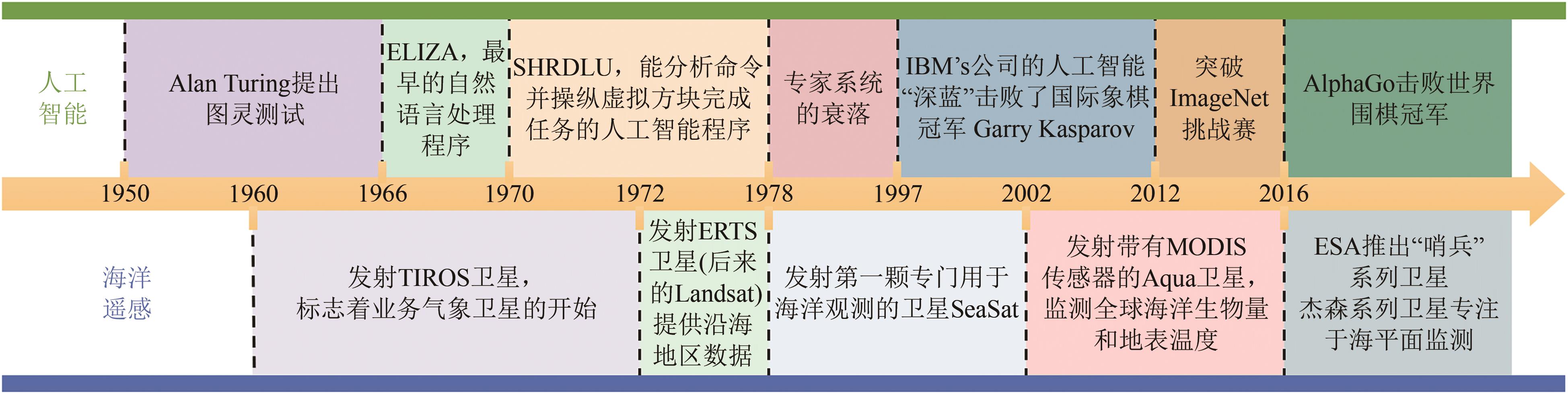 摘要:Over the past 40 years, remote sensing technology has advanced significantly, facilitating ocean observation and propelling the field into the era of big data. However, the enormous amount of data generated by ocean remote sensing, coupled with the complexity of these datasets, presents a major challenge for traditional data processing methods. As Artificial Intelligence (AI), particularly Deep Learning (DL), has developed rapidly in recent years, it has emerged as a powerful tool to address these challenges.This study highlights key areas where AI has been applied to ocean remote sensing, notably in ocean parameter retrieval, subsurface data reconstruction, super-resolution techniques, and information extraction from ocean remote sensing images. For instance, AI-driven DL models have been developed to improve the accuracy of sea surface wind field retrieval using Synthetic Aperture Radar (SAR) data, especially under extreme weather conditions such as typhoons or hurricanes. Additionally, AI methods have enhanced the retrieval of chlorophyll-a concentrations in the ocean, with AI models outperforming traditional algorithms in precision and adaptability.Another significant application of AI in ocean remote sensing discussed in the article is the reconstruction of three-dimensional ocean fields. Traditional observation methods, both in situ and satellite-based, face limitations in spatial and temporal resolution, particularly in subsurface ocean observations. AI-based models, such as Convolutional Neural Networks (CNN), have been employed to reconstruct subsurface ocean data, filling gaps in observational datasets and providing a more comprehensive understanding of ocean dynamics.We also explore the use of AI for super-resolution tasks in Sea Surface Temperature (SST) estimation. Through advanced deep learning models, low-resolution SST data can be enhanced to meet the increasing demand for high-resolution data in coastal and regional studies. The integration of AI has not only improved the spatial resolution of SST data but has also enabled better predictions and monitoring of ocean ecosystems, including coral bleaching events and fishery management.Furthermore, AI plays a crucial role in extracting information from ocean remote sensing images, such as identifying mesoscale eddies and internal waves. These oceanographic features have important implications for ocean circulation, climate variability, and ocean biogeochemical processes. AI-based models, with their superior feature extraction capabilities, can identify and classify these features with high precision, surpassing traditional image processing methods.Finally, we concludes by discussing future trends and challenges in the application of AI to ocean remote sensing. It emphasizes the need for further research to integrate physical oceanographic knowledge with data-driven AI models. The combination of AI technology and ocean science theories will enhance the accuracy and reliability of future oceanographic models and contribute to a deeper understanding of ocean processes.关键词:ocean remote sensing;artificial intelligence;deep learning;ocean parameter inversion;super resolution techniques;3D ocean field reconstruction;ocean information extraction500|680|0更新时间:2025-09-01
 - “最新研究揭示了农作物早期分类的关键技术与发展方向,为粮食安全提供数据支撑。”
 摘要:Timely and accurate acquisition of spatial distribution information on crop planting is critically important for crop growth monitoring, yield forecasting, agricultural planning, and management, among other applications. Such information serves as a critical data foundation for ensuring global food security. Thus far, the limitations of postseason crop classification in meeting the demand for timeliness have prompted a gradual shift in research focus toward early-season crop classification. This study systematically reviews relevant studies published since 2014 to clarify the developmental directions of early-season crop classification research. These studies are retrieved from the Web of Science and CNKI databases. The review categorizes and summarizes the recent research progress in terms of data and preprocessing methods, sample selection, feature selection, classification strategies, and accuracy evaluation metrics. The analysis indicates that several unresolved challenges persist in current studies, including the enhancement of early-season features, the optimization of classification strategies, and the selection of reliable samples. These areas represent key focal points and challenges for future research, thereby meriting further in-depth exploration. This review aims to provide valuable insights into the methods and strategies of early-season crop classification, understand its challenges and developmental directions deeply, and contribute to the advancement of theories and technologies in early-season crop classification.关键词:remote sensing;crop classification;early-season;time-series analysis;key phenological period;machine learning;deep learning340|557|0更新时间:2025-09-01
 - “农业遥感技术在全球人口增长和环境变化下,推动农业粮食体系数字转型,实现“四个更好”。专家系统综述了农业遥感发展历程、问题及途径,为提升农业生产智慧化水平提供解决方案。”
 摘要:Against the dual pressures of global population growth and evolving socio- natural environmental dynamics, agrifood systems face unprecedented challenges in ensuring food security, maintaining socio-economic stability, preserving ecological integrity, and achieving sustainable development. How agricultural remote sensing can drive the digital transformation of agri-food systems and to realize the “Four Betters” goals (Better Production, Better Nutrition, Better Environment, and Better Life) is a pressing issue that requires systematic planning. This review systematically examines the developments, current gaps, and future pathways of agricultural remote sensing development from three perspectives: remote sensing-based agricultural monitoring, developing and sharing of agricultural data products, and practical implementation of agricultural remote sensing technologies. Significant advancements in agricultural remote sensing have been achieved in innovative methodological development (e.g., automated self-learning algorithms) and multi-source data fusion for in-depth information extraction in agricultural production. However, critical gaps persist in three domains. First, the maturation and standardization of agricultural remote sensing techniques, for example, current deep learning algorithms demonstrate excellent performance in controlled experiments but face significant generalization challenges in real-world applications due to sample/lable data constraints and transferability to target spatial and temporal domain. In addition, the production and dissemination of high-quality, standardized large-scale and long-term agricultural data products remain critical challenges that require urgent attention. Currently, only major crops have regional or global scale remote sensing-derived data products, while crucial agricultural management parameters (e.g., irrigation, fertilization) lack standardized monitoring frameworks. The existing data products suffer from the temporal discontinuity, spatial inconsistency and the validation deficiencies (the point-based verification, not the field-boundary based Validation). While crop identification, crop growth monitoring, and yield prediction are the research focus, there are no adequate attention paid for monitoring the complex cropping systems (intercropping, relay cropping), non-grain conversion and field management practice and so on. What’s more, there is an even greater lack of development of standardized data products for crop growth monitoring and yield estimation. Besides, the transformation of agricultural remote sensing outputs into actionable decision-support systems remains a critical bottleneck in realizing the full potential of precision agriculture due to the data-to-decision latency, inadequate integration with farm management systems and the limited contextualization for diverse end-users. Moving forward, strategic priorities should focus on the following aspects. The integration of artificial intelligence (AI), big data, and domain-specific foundation models (e.g., Agri-GPT) represents a transformative leap for agricultural remote sensing, significantly enhancing model robustness, generalizability, and operational replicability. This technological integration is being institutionalized through comprehensive data platforms featuring standardized protocols and nationally unified service frameworks, characterized by the development of agricultural-specific transformer models trained on multi-year, multi-sensor satellite data and high-resolution UAV data for mapping diverse crop varieties. These platforms incorporate open-source model hubs with pre-trained and domain adaptation tools for regional customization, enabling seamless deployment across different agricultural systems. These advancements collectively establish an intelligent agricultural monitoring infrastructure that supports both precision farming and national food security strategies, projected to improve annual income through enhanced input efficiency and reduced monitoring costs, and optimize synergies between agricultural productivity and ecosystem services and serve as a replicable model for cross-disciplinary remote sensing applications.关键词:agrifood systems;agricultural remote sensing;development and standardization of data product;artificial intelligence;remote sensing large models246|621|0更新时间:2025-09-01
 - “全球农情遥感监测云服务平台CropWatch的最新进展,构建了监测技术体系,实现了农情监测模型的全球验证,促进了发展中国家农情监测能力的发展。”
 摘要:Agricultural condition monitoring is a critical link in the food supply chain, and its accuracy and reliability are vital for agricultural production management, macro-control of grain, market stability, and sustainable development. Global agricultural remote sensing monitoring plays a vital role in ensuring food security, which is especially prominent for China, the world’s largest food-importing country. Remote sensing has become an important means of agricultural condition monitoring. because it can provide extensive, high-frequency, and timely monitoring data. However, due to various factors, global agricultural condition monitoring still faces many challenges. The global agricultural monitoring system, CropWatch, is a monitoring system driven by remote sensing indicators and ground-measured data, providing independent global agricultural condition information, independent of statistical data, which has been stably operating for over 27 years, has released 135 agricultural monitoring reports to date, providing agricultural information services to 173 countries and regions worldwide. This article details the latest developments of CropWatch over the past five years, forming a monitoring system composed of 54 indicators, adding cultivation and early warning indicators, and highlighting monitoring and early warning functions. Using the advanced machine learning methods, it has constructed a foundation of basic data such as “farmland (field), irrigation, cropping intensity, terraces, shelterbelts,” achieving independence in basic data. The use of large language models has significantly improved the efficiency and objectivity of agricultural condition indicator analysis. In the future, a more open agricultural observation platform will be built, supported by large language models and open APIs, to lower the barriers to use.With its unique design philosophy and operational mechanism, the CropWatch agricultural monitoring system stands out in the international agricultural monitoring field and sets an example for the operationalization of remote sensing monitoring. After seven versions of updates, the current CropWatch has achieved cloud-based and service-oriented operations. It can serve all interested users or stakeholders, enabling them to customize the monitoring system and conduct independent monitoring based on their own agricultural characteristics and needs, thereby enhancing their autonomy in monitoring. Through capacity building and the empowerment of independent agricultural monitoring, users are enabled to independently undertake the construction of agricultural monitoring systems for specific regions, as well as the production of agricultural products, collaborative analysis of information, and dissemination of results. This customized solution not only reduces users’ dependence on expensive computing infrastructure and storage devices but also, by opening up model functionalities, allows users to independently verify and calibrate models within a user-friendly interface. This reduces technical barriers and reliance on external information, enhancing the flexibility and operability of monitoring and providing a more flexible and efficient solution for agricultural monitoring. This has revolutionized the traditional model of agricultural monitoring system development and has promoted the capacity for agricultural monitoring in developing countries.Looking to the future, CropWatch will further build a more open agricultural monitoring platform, strengthen the protection of data privacy and sovereignty, and with the support of large language models and open APIs, create an efficient, reliable, and user-friendly agricultural monitoring system. This will serve global agricultural producers and decision-makers, provide strong support for global food security and sustainable development, and promote the popularization and in-depth application of agricultural monitoring technologies.关键词:agricultural condition monitoring;CropWatch;global application;global verification;remote sensing260|162|0更新时间:2025-09-01
 - “滨海湿地遥感研究进展:从分布范围到生态系统功能,为湿地保护提供科学依据。”
 摘要:Coastal wetlands are transitional zones connecting terrestrial and marine ecosystems, characterized by unique structures and functions, encompassing mangroves, salt marshes, tidal flats, coral reefs, seagrass beds, and so on. These ecosystems collectively represent one of Earth’s most productive biogeochemical systems, where the interplay of tidal dynamics, vegetation zonation, and sediment transport creates distinct ecological niches. They play a crucial role in carbon sequestration and provide critical habitats for various plant and animal species, thereby effectively supporting biodiversity and ecosystem health. The complex feedback mechanisms and dynamic changes in these areas require monitoring approaches capable of capturing multi-scale dynamics. Remote sensing has the capacity to assist in the monitoring, conservation, and sustainable management of these vital ecosystems by providing spatially explicit, cost-effective, and temporally consistent observations. Coastal wetland remote sensing, as an interdisciplinary field, dates back to the 1970s. Over the past 50 years, the focus of coastal wetland remote sensing research has evolved from mapping distribution and retrieving ecological parameters to investigating ecosystem functions and material cycles. This trend indicates that the remote sensing of coastal wetlands has a promising future in supporting ecosystem-based management and global change research. In this study, we retrieved relevant publications on coastal wetland remote sensing from the Web of Science Core Collection and used VOSviewer to identify key research themes, which were then chronologically divided into five historical phases: before 1989, 1990—1999, 2000—2009, 2010—2019 and 2020 to the present. By linking research themes to the emergence of new sensors, we revealed the historical evolution and current status of coastal wetland remote sensing. This sensor-theme coupling analysis revealed pivotal technological transitions that facilitated novel insights into coastal wetland remote sensing processes. For each research theme, we analyzed the first published article and the most cited articles, providing an in-depth examination of the developmental trajectory of each theme. Importantly, our analysis demonstrates that coastal wetland remote sensing has evolved from early extent mapping to structural parameter retrieval, then physiological trait estimation, and ultimately ecosystem function assessment and biogeochemical cycle quantification, reflecting a paradigm shift from pattern observation to in-depth ecological process. Finally, we outlined future research directions from four aspects: large-scale classification and mapping, fine-scale inversion of ecological parameters, remote sensing and climate change model and comprehensive remote sensing of ecosystem services. These priorities emphasize the need for multi-sensor fusion, tighter integration with ecological process models, and transformative applications of artificial intelligence technologies. This study provides valuable insights into the history, key research areas and future directions of coastal wetland remote sensing, and reinforces the significance of coastal wetland remote sensing in ecosystem-based management, particularly in addressing emerging global and climate change challenges. Through a systematic review of multidisciplinary research progress over the past five decades, this study synthesizes the co-evolutionary dynamics between sensor technology advancements and wetland ecological research needs. It also outlines critical future development trajectories, offering guidance for researchers in developing forward-looking and targeted research strategies, and providing policymakers with scientific evidence to promote effective conservation and sustainable management of coastal wetlands under accelerating environmental pressures.关键词:coastal wetlands;remote sensing;review;research hotspots;research progress221|476|0更新时间:2025-09-01
 - “激光雷达LiDAR技术在生态与地学领域取得突破,推动了点云配准、点云分割与分类等算法的发展,为解决地形测绘、地质灾害监测等问题提供解决方案。”
 摘要:LiDAR (Light Detection and Ranging) is one of the most innovative technologies in the field of remote sensing, capable of accurately reconstructing the three-dimensional (3D) structures of the objects being measured. Over the past few decades, LiDAR technology has advanced rapidly, significantly promoting research in the field of ecology and geosciences. This paper systematically reviews and explores the potential future developments in LiDAR hardware and algorithms, as well as their applications in ecology and geosciences.We first pointed out that, driven largely by the rapid advancements of autonomous driving technology, LiDAR hardware has demonstrated a trend towards diversification and enhanced precision. Types of near-ground LiDAR platforms have been particularly enriched, enabling efficient and high-resolution data acquisition at unprecedented spatial and temporal scales. Meanwhile, due to the progress of artificial intelligence technologies such as deep learning, Simultaneous Localization and Mapping (SLAM), and Large Language Model, LiDAR algorithms have also achieved significant development, leading to continuous innovations in point cloud registration, segmentation, classification, and the fusion of point clouds with multi-source data. Regarding LiDAR’s applications in ecology and geosciences, we detailed the applications of LiDAR in 11 research topics of ecology and geosciences: inland topographic mapping, ocean mapping, geological hazard monitoring, forest structure measurement, tree branching networks modeling, 3D radiative transfer and scene reconstruction, forest microclimate simulation, intelligent agriculture, biodiversity monitoring, urban and architectural studies, and planetary survey. Our comprehensive review underscores LiDAR’s versatility and its critical role in advancing both theoretical and applied ecological and geoscience research.Looking ahead, with the continuous advancement of hardware, algorithms, and LiDAR big data, LiDAR will continue to revolutionize research in ecology and geosciences and is poised to play a pivotal role in an even broader range of fields. For instance, combining LiDAR-derived 3D structural information with radiative transfer modeling, computational fluid dynamics, and plant physiology offers the potential to simulate essential biological processes such as photosynthesis, transpiration, and respiration. The advancement of multispectral and hyperspectral LiDAR systems is expected to tackle the challenge in species identification and vegetation trait quantification, opening possible new frontiers in biodiversity and functional ecology. At a broader scale, LiDAR is expected to support the implementation of “Realistic 3D China,” a comprehensive digital twin of the nation’s surface environment. In addition, LiDAR will be increasingly applied to underground remote sensing, power infrastructure inspection, and Earth system monitoring. In terms of big data, the establishment of LiDARNET (https://lidar.pku.edu.cn/[2025-04-14]), a national open-access platform for near-surface LiDAR data, represents a key milestone in enabling data standardization and large-scale collaboration. With the establishment of LiDARNET and other LiDAR data sharing platforms, the availability of high-resolution LiDAR datasets will be continuously augmented, providing critical foundations for the development of next-generation global vegetation dynamic models and enabling more accurate forecasting and management of ecosystem processes at multiple scales.In short, LiDAR is emerging as a pivotal technology in shaping the future of Earth observation, plant ecology, animal ecology, urban ecology, and a range disciplines of geosciences. With the ongoing advancements in hardware design, algorithm development, and high-resolution LiDAR big data, LiDAR is committed to drive transformative breakthroughs across more research fields.关键词:lidar;UAV;SLAM;deep learning;Large Language Model;forest;ocean;Planetary Survey603|2185|0更新时间:2025-09-01
 - “在非暴露空间探测领域,专家设计了自主空中无人系统,实现了高效自主探测,为深地深空探测提供新方案。”
 摘要:Non-exposed spaces, such as indoor environments, underground utility tunnels, and natural caves, are partially enclosed areas that have gained increasing attention as urbanization progresses. This growing demand for exploration has significant implications. Investigating these spaces and acquiring spatial information within them can support the development of new infrastructure and facilitate digital transformation. However, exploring non-exposed spaces presents several challenges due to their complex structures, signal isolation from external sources, and degraded conditions. In such spaces, external positioning signals, such as GNSS, are often unavailable, complicating the reliance on these signals for localization. Additionally, many non-exposed spaces suffer from degraded environmental conditions, which further hinder self-localization. The intricate internal structures of these spaces also pose safety risks for human entry. The advancement of unmanned systems technology presents a promising solution to these challenges. To address these issues, we designed an autonomous aerial unmanned system equipped with panoramic LiDAR, providing a wide field of view, and integrated with modules for localization, mapping, planning, and control, enabling autonomous flight in uncharted spaces. The system consists of five main components: sensor input, localization and mapping, planning, control, and the unmanned system itself. Sensor data from LiDAR and IMU are utilized for state estimation and real-time mapping. The system generates an occupancy grid map for trajectory planning, followed by optimization. Commands are then sent to the flight controller, which integrates manual and planned inputs to maintain stable flight. The system’s pose is monitored through Mavros, ensuring autonomous flight by controlling the motors via ESCs. Additionally, we propose a method for autonomous exploration of non-exposed spaces that involves point cloud mapping based on manually or autonomously assigned target points on a pre-established map. To validate the proposed autonomous aerial unmanned system and exploration method, we conducted experimental verifications in both simulated and real-world scenarios. We first selected a typical indoor scenario, “Indoor1,” within the XTDrone simulation environment under GNSS-denied conditions. The simulation utilized the Iris drone, supported by PX4 firmware with PX4 software-in-the-loop communication, and an Intel RealSense D455 simulation module for capturing visible and depth images. The simulation results demonstrated a detection efficiency of 23.94 m³/s using the proposed exploration method. Subsequently, real-world experiments were conducted in a section of an underground parking lot at Wuhan University’s Xinghu Experimental Building. The autonomous aerial unmanned system demonstrated stable flight, achieving a detection efficiency of 53.94 m³/s in complex environments, such as corridors, pipelines, and rooms. The experimental results confirm the feasibility of the proposed method. Real-world experiments achieved a exploration efficiency exceeding 50% m³/s, validating the system's capability to efficiently explore non-exposed spaces. This demonstrates the significant potential of the system for future applications. Further research will focus on viewpoint generation based on specific targets to enhance the system's intelligence, enabling intelligent exploration of non-exposed spaces. This will improve the system’s autonomy and adaptability in complex environments.关键词:non-exposed space;unmanned autonomous mapping;aerial unmanned system;path planning;SLAM276|517|0更新时间:2025-09-01
 - “在“全球变化及应对”重点专项中,科技部资助了“山地生态系统全球变化关键参数立体观测与高分辨率产品研制”项目。项目预期将提出1套山地生态系统全球变化关键参数立体综合观测实验适用技术,生产王朗典型山地区域14种关键参数、高分辨率参考“真值”产品,形成11种关键参数的高分辨率产品生产能力,研制出世界首套覆盖全球山地7种关键参数、25年、逐月、30 m高分辨率数据集产品。研究成果将促进中国对全球山地生态系统的综合监测能力,为山地全球变化和可持续发展研究,特别是山区生态环境保护、防灾减灾、农业生产、水资源管理等提供科学数据和技术支撑。”
 摘要:Mountains serve as sentinels of global change, exhibiting an accelerated warming trend with increasing elevation. Global change directly impacts critical mountain surface processes including hydrological cycles, ecological dynamics, and biogeochemical fluxes, thereby threatening future water resource availability and ecosystem services in mountainous regions. While remote sensing Earth observation provides essential data sources for studying mountain ecosystem dynamics, most existing global change remote sensing datasets exhibit kilometer-level spatial resolutions that inadequately characterize the intense spatiotemporal heterogeneity of mountain surfaces. There is an urgent need for high spatiotemporal resolution, spatially seamless, and accuracy-reliable remote sensing products to enhance scientific understanding of mountain ecosystems’ responses and adaptations to global change. In recent years, the mountain remote sensing modeling and parameter retrieving algorithms have witnessed significant advances, where comprehensive field observation platforms for typical mountainous regions have been established. These developments have laid a solid foundation for conducting stereoscopic monitoring of global change-critical parameters in mountain ecosystems and subsequent high-resolution product development. Addressing the requirements for stereoscopic observation and high-resolution monitoring products in mountain ecosystems, the Ministry of Science and Technology of China funded the project named “the stereoscopic observation and high spatial resolution products development of key global change parameters for mountain ecosystem” (2020—2025) in the key programme of “Global Change and Response” under the National Key Research and Development Plan during the 13th Five-Year Plan period. This paper outlines the project’s background, key scientific challenges, research objectives, implementation framework, and expected outcomes. It systematically reviews progress achieved in establishing near-surface stereoscopic observation systems, spatiotemporal scaling expansion methods, remote sensing retrieval models, and product development for global change parameters in mountain ecosystems. This project will establish ground-aerial-satellite stereoscopic observation technology by combining ground-based, aerial, and satellite platforms across different topographic gradients and ecosystem types through terrain-specific experimental designs, and will develop the spatiotemporal scaling expansion models for complex terrains to create high-resolution reference “truth” products for Wanglang mountainous regions. The project will also develop terrain-adapted remote sensing retrieval models, and produce the world’s first set of global mountain remote sensing products featuring seven key parameters at 30m spatial resolution with monthly temporal resolution. The project is expected to propose a set of applicable technology for three-dimensional comprehensive observation of key parameters of global changes in mountain ecosystems, produce 14 kinds of key parameters and high-resolution reference “truth” products in typical mountain areas of Wanglang, and form a high-resolution product production capacity of 11 kinds of key parameters. The world’s first set of global mountain remote sensing products with 7 key parameters, 25 years (2000—2024), monthly, 30 meters high-resolution will be produced. The project is expected to promote China’s comprehensive monitoring capability of the global mountain ecosystem, and provide scientific data and technical support for research on global mountain change and the sustainable development of mountain society, especially mountain ecological environment protection, disaster prevention and reduction, agricultural production and water resources management.关键词:mountain;global change;stereo observation;remote sensing products;high resolution198|436|0更新时间:2025-09-01
 - “激光雷达技术在森林生物量估测领域的研究进展,为提高估测精度提供解决方案。”摘要:Forests as the largest carbon sink in the terrestrial ecosystems play important roles in mitigating climate change and maintaining ecological balance, thus, it is required to accurately map forest biomass distribution at timely manner. Remote sensing-based biomass estimation has obtained great attention in the past three decades, in particular, LiDAR due to its capability of capturing three-dimensional structure of forest stands has become an important data source for forest biomass estimation. LiDAR data can be acquired from different platforms such as close-ground, airborne and spaceborne, thus, they are used for biomass estimation at different scales such as individual trees, forest stands and landscapes. Many studies using LiDAR data for forest biomass estimation have been conducted, but no comprehensive review has been made so far. Therefore, this paper attempts to provide an overview of current situations of using LiDAR technologies for forest biomass estimation and discuss the challenges and potential solutions to improve biomass modeling performance at different scales. The research situations and existing problems on the biomass estimation at individual tree, plot, and landscape scales based on LiDAR data from different platforms (e.g., close-ground, airborne and spaceborne) were first described and the combination of LiDAR and other data sources such as optical, microwave radar, and auxiliary data for improvement of forest biomass estimation were then summarized and discussed; Different modeling methods such as regression, machine learning, deep learning, and hybrid methods were overviewed and the potential solutions to improve modeling accuracy through stratification were discussed; The potential factors causing biomass estimation uncertainty, the methods for examining and identifying uncertainty factors were described and then potential strategies to optimize the modeling procedure were discussed; The model transferability at time and space scales and the importance and challenge of constructing a universal forest biomass estimation model were then discussed. This paper highlighted the unique characteristics of LiDAR data from different platforms and indicated the necessity of incorporating LiDAR with other remotely sensed data for improving forest biomass estimation. This paper also indicated the importance of developing an optimized modeling procedure through examining modeling uncertainty and the values of developing a universal biomass estimation model through combination of physically based models and machine learning methods. This paper provided researchers a better understanding of the current situations of LiDAR technologies in forest biomass estimation research, and new insights for better employing relevant LiDAR data for improving forest biomass estimation at different scales.关键词:forest biomass;close-ground LiDAR;airborne LiDAR;spaceborne LiDAR;multi-source data;modeling methods;uncertainty analysis;model transferability;model universality359|638|0更新时间:2025-09-01
- “遥感技术在植被病虫害监测预警领域取得显著进展,多源数据融合与综合运用是未来研究重点,为病虫害绿色防控提供支撑。”
 摘要:Vegetation diseases and pests pose significant threats to agricultural and forestry production, as well as to ecosystem health. In the context of global climate change, these impacts are further exacerbated. Effective, precise, and environmentally friendly control of diseases and pests relies heavily on high-quality monitoring and forecasting information. Compared to traditional vegetation protection methods, the rapidly advancing remote sensing technology is increasingly recognized by scientists and governments worldwide for its potential in disease and pest monitoring. This paper systematically reviews the recent applications of remote sensing technology in the monitoring and forecasting of vegetation diseases and pests, focusing on the advancements in techniques, methods, and models. It analyzes the current major challenges in this field and discuss future development trends. Firstly, the multi-scale remote sensing observation data composed of satellite, aviation, UAV remote sensing and near-ground sensors with increasingly enriched modes and improved performance and accuracy provide key data source for monitoring and habitat evaluation of vegetation diseases and pests. In terms of remote sensing monitoring tasks, spectral analysis and image analysis are two primary methods used to extract key information sensitive to diseases and pests from remote sensing data. Meanwhile, the application of temporal analysis techniques offers effective tools for monitoring disease and pest processes and discrimination among different stressors. For remote sensing-based forecasting of diseases and pests, multi-source remote sensing information is employed to monitor various habitat factors. The information coupled with various statistical models, machine learning models, deep learning models, or mechanistic models to achieve large-scale early warnings of diseases and pests. The integration of remote sensing information enables the expansion of the capability from specific points to wider areas, evolving from static to dynamic, and forming large-scale spatiotemporal dynamic predictions. In the future, it is necessary to further strengthen the fusion and comprehensive application of multi-source remote sensing data in view of the important challenges still existing in the research of remote sensing monitoring and forecasting of diseases and pests, including the complexity of spectral characteristics, data quality, data processing efficiency, model applicability and generalization ability. Particularly, it is important to explore the potential applications of fluorescence, thermal infrared, LiDAR, and other remote sensing ways in the monitoring and forecasting tasks. On this basis, it is essential to carry out interdisciplinary comprehensive research that integrates remote sensing technology, artificial intelligence, and plant protection theoretical models to fully explore and unleash the potential and value contained in multi-source remote sensing data. This will support the establishment of a more timely, accurate, efficient, and dynamic disease and pest monitoring and forecasting system, ultimately better serving the integrated management and environmentally friendly control of vegetation diseases and pests.关键词:vegetation pest and disease;remote sensing;monitoring;forecasting;progress231|380|0更新时间:2025-09-01
 - “在农、林、生态、环境等领域,低空无人机植被定量遥感技术研究取得新进展,系统梳理了技术链条与知识体系,为解决精细时空尺度植被监测问题提供解决方案。”
 摘要:Spatiotemporal fine-scale vegetation monitoring has been a key component in applications across agriculture, forestry, ecology, and environmental fields. Low-altitude Unmanned Aerial Vehicle (UAV) -based quantitative remote sensing of vegetation is one of the most effective techniques for fine-scale monitoring. The advantages such as ultra-high spatial resolution, outstanding flight flexibility, high-frequency data acquisition capability, capability of obtaining multi-modal data, and exceptional geographical accessibility, enable UAV-based remote sensing can be tailored for specific ecological, agricultural and other needs. Compared to satellite-based remote sensing. UAV remote sensing exhibits significant differences in data acquisition modes (such as radiometric and geometric imaging, laser scanning) and data characteristics (such as ground sampling distance, data richness, and data modality), gradually leading to a unique methodology and technical framework.Since 2010, the UAV remote sensing -related research has grown explosively. A significant increase in publications, technical innovations, and interdisciplinary applications has demonstrated its expanding impact across various scientific and industrial domains. However, a comprehensive and systematic exposition of its knowledge structure is still lacking. In particular, its theoretical scope, technical framework, current advance, key challenges and potentials remain fragmented. Despite numerous studies focusing on specific UAV applications, a holistic synthesis is required to integrate scattered knowledge and establish a standardized methodology for vegetation monitoring.To address this, the present paper introduced the basic objectives of UAV-based quantitative remote sensing of vegetation, presented its technical chain and knowledge hierarchy. The paper systematically summarized the current status, advances, and unresolved issues in four key areas: active and passive remote sensing data acquisition (including UAV platforms, typical sensors, flight mode and configuration), data pre-processing (including image radiometric correction, image geometric correction, and point cloud pre-processing), physically and empirically -based modeling (including ultra-high-resolution radiative transfer modelling and machine learning modelling), and vegetation properties monitoring (including retrieval of vegetation variables, object recognition of vegetation and geometric measurement of vegetation), where each of these areas plays a crucial role in improving the reliability and applicability of UAV-based vegetation monitoring. Furthermore, the study identified several key challenges and potential solutions, particularly in data preprocessing (such as radiometric correction in complex illumination conditions and real-time onboard geometric correction) and vegetation properties monitoring (such as centimetric-resolution retrieval of vegetation variables, fundamental models or highly-generalizable task-oriented deep learning models). Against the backdrop of the Chinese national strategy “low-altitude economy”, low-altitude UAV-based quantitative remote sensing of vegetation is poised to play an increasingly irreplaceable role in agriculture, forestry, ecology, environmental management, and emergency response fields.关键词:UAV-based remote sensing of vegetation;radiometric and geometric correction;physically and empirically -based modelling;ultra-high-resolution retrieval of vegetation properties;vegetation object identification and measuring432|737|0更新时间:2025-09-01
 - “森林可燃物遥感反演理论与方法体系,为森林火灾精准防控提供数据支撑。”
 摘要:In recent years, forest fires have ravaged globally, emitting substantial greenhouse gases, severely disrupting natural environments, and posing significant threats to human lives, property, and ecosystems. Accurate forest fire risk prevention and control are urgently needed. The fire triangle model highlights weather, topography, and fuel as the three key factors influencing fire ignition and propagation. Forest fuels, encompassing all combustible materials, provide the material basis and energy source for fires, and play a critical role in affecting fire behavior. These fuels are categorized by vitality (live/dead) and vertical stratification (canopy/surface). Canopy live fuels and surface dead fuels serve as primary combustion bases for crown fires, surface fires, and ground fires. Their properties—moisture content (ratio of water to dry mass) and load (dry mass per unit area)—directly affect flammability, fire intensity and spreading. Therefore, accurate dynamic monitoring of Live Fuel Moisture Content (LFMC), Live Fuel Load (LFL), Dead Fuel Moisture Content (DFMC), and Dead Fuel Load (DFL) is essential for fire risk assessment. Although traditional field sampling methods yield precise measurements, their high costs and limited spatial scalability hinder large-area applications. Remote sensing technology has emerged as a transformative solution, enabling large-scale fuel variable estimation.However, persistent challenges remain. Early studies employed empirical regression models combining ground data and satellite spectral features (e.g., vegetation indices) to estimate canopy LFMC, yet these models suffered from limited generalizability due to local heterogeneity and sensor variability. Radiative Transfer Models (RTMs) improved mechanistic interpretability by explicitly modeling soil-canopy-spectral interactions but face some challenges: 1) ill-posed inversion issues from spectral similarity across parameter combinations; 2) weak sensitivity of parameters like dry matter content in heterogeneous canopies; and 3) inability of single-layer homogeneous assumptions to represent vertically stratified forests (e.g., tree-shrub-grass layers). LFL was estimated based on optical (vegetation indices, texture features), SAR (backscatter coefficients, polarization parameters), LiDAR (canopy height percentiles, waveform metrics), and multi-source fusion methods. Machine learning models (e.g., random forests) enhance multi-sensor synergies, but they are still constrained by parameter sensitivity and inversion instability for large-scale applications. DFMC estimations rely on linear relationships between remote sensing parameters (e.g., Landsat thermal bands) or satellite-derived meteorological variables (temperature, humidity), yet are limited by ground data dependency and insufficient integration of hydrothermal theory. DFL estimations predominantly employ LiDAR (terrestrial/spaceborne) for 3D structural characterization but struggle with cost, data availability, and empirical model reliance.To address these challenges, this study developed a comprehensive framework integrating hierarchical radiative transfer models and ecological processes. LFMC inversion adopted stratified modeling: PROSAIL for grasslands and PROGeoSAIL for upper forest layers, with PROSAIL for understory. Global sensitivity analysis identified key parameters (equivalent water thickness, dry matter content), and look-up table algorithms with spectral matching achieved global LFMC mapping (R²=0.71, RMSE=32.36%) validated by 3,034 field samples across 120 sites. LFL estimations focused on foliar fuels, coupling GeoSAIL-SAIL-PROSPECT models to retrieve leaf area index (LAI), coverage, and dry matter content. Pre- and post-fire comparisons of the 2024 Yajiang forest fire case demonstrated the model’s capability to quantify fuel load dynamics. DFMC monitoring integrated process models with geostationary satellite data: Sobol sensitivity analysis identified relative humidity as the dominant driver, derived from energy-balance-based air temperature inversion and meteorological interpolation. The Yajiang case revealed declining DFMC trends pre-ignition, aligning with fire risk patterns. DFL estimations combined long-term LFL inversion with Olson’s decomposition model, simulating annual litter accumulation and decay driven by climate. Validation in Liangshan Yi Autonomous Prefecture showed DFL spatial patterns (higher in the north, lower in the south) consistent with regional climate-vegetation interactions.This study demonstrates the efficacy of integrating multi-model coupling with multi-source data synergy in complex forest ecosystems, establishing a robust scientific framework for high-precision retrieval of multi-category fuel parameters. Enabling accurate quantification of critical fuel characteristics, can significantly improve predictive accuracy in wildfire risk assessment and behavior modeling, thereby delivering critical technical support for data-driven fire prevention strategies and precision forest management.关键词:multi-category fuels;fuel moisture content;fuel load;remote sensing retrieval;forest fire risk218|524|0更新时间:2025-09-01
 - “在AI+时代,湖泊遥感领域取得新进展,专家探索了多源综合观测模式,为掌握湖泊动态及未来变化趋势提供新可能。”
 摘要:With the intensification of climate change and human activities, lake ecosystems are undergoing significant changes in hydrological processes, thermodynamic characteristics, and ecological equilibrium, exhibiting complex spatiotemporal response patterns. The rapid advancement of deep learning and other AI technologies has significantly enhanced the role of remote sensing big data in revealing spatiotemporal changes in lakes. Building upon previous research, this paper systematically reviews the latest developments in the field of lake remote sensing in the AI era, emphasizing the growing attention to climate change, particularly the comprehensive responses of lakes under increasing occurrences of extreme weather events like heatwaves. To address the rapid changes in lake ecosystems at different spatial and temporal scales, remote sensing observations are transitioning from single data sources to a multi-source integrated observation model of “virtual constellations + sky-ground integrated networking,” greatly enhancing the accuracy and coverage of dynamic lake monitoring across multiple scales and dimensions. Furthermore, remote sensing models are evolving from traditional empirical/mechanistic models to a dual-driven mechanism of “explicit mechanistic models + implicit machine learning models,” gradually improving the simulation and predictive capabilities of hydrological, thermodynamic, and biological processes. This paper also explores the integration of remote sensing big data with intelligent AI algorithms, highlighting their potential applications in long-term monitoring and future scenario predictions, offering insights into understanding the dynamic changes and trends of lakes under complex environmental pressures.关键词:lake remote sensing;AI;climate change;aglorithm189|236|0更新时间:2025-09-01
 - “卫星遥感技术在地表水体监测领域取得显著进展,专家综述了遥感数据源、提取方法、应用及挑战,为水资源管理提供新方案。”
 摘要:Inland surface waters, a critical freshwater resource, have undergone significant changes due to the combined impacts of climate change and human activities, underscoring the need for effective detection and monitoring of their distribution and spatiotemporal dynamics. Satellite remote sensing technology, with its broad spatial coverage, long-term historical data availability, and cost-effectiveness, has emerged as a key tool for tracking changes in inland water resources. Water bodies exhibit distinct characteristics in remote sensing images, enabling detailed quantitative analysis of their extent and changes over time through the application of appropriate water extraction algorithms on multi-temporal remote sensing imagery from various sources.This paper provides a comprehensive review of current research on the detection and monitoring of inland surface waters, focusing on four key areas: commonly used remote sensing data sources, state-of-the-art water extraction methods, insightful remote sensing applications, and the associated challenges and future directions. Both optical and microwave remote sensing data offer unique advantages and play crucial roles, with the integration of data from different sensors showing considerable promise. Traditional threshold-based methods identify water bodies by setting specific spectral thresholds, while machine learning classification algorithms leverage a combination of spectral, textural, spatial, and geometric features for water body extraction. Other approaches also perform well in specific scenarios. In recent decades, significant progress has been made in the use of satellite remote sensing to monitor the extent of inland surface waters, leading to the development of various large-scale and long-term rasterized, vectorized, and digitized surface water datasets, as well as new insights into the spatial and temporal dynamics of the global surface water bodies and their driving forces. Finally, this paper suggests potential solutions to challenges including the trade-off between spatial and temporal resolution and monitoring in conditions of contamination and obscured by vegetation, while exploring the future prospects and challenges of water detection in a new era of remote sensing big data. This paper seeks to provide a comprehensive reference and practical guidance for researchers, practitioners, and decision-makers interested in harnessing remote sensing technologies for the study and advanced surveillance of inland water bodies.关键词:remote sensing;inland water;water detection;dynamics monitoring;review399|949|0更新时间:2025-09-01
 - “自2013年以来,日光诱导叶绿素荧光卫星遥感技术快速发展,成为全球生态监测、碳循环研究及农业生产力评估的重要手段。SIF技术在空间分辨率和反演精度上取得显著提升,为全球变化和碳循环动态研究提供新方向。”
 摘要:Over the last decade, satellite-based Solar-Tnduced chlorophyll Fluorescence (SIF) remote sensing has revolutionized the monitoring of vegetation photosynthesis, carbon cycling, and ecosystem dynamics. Unlike traditional vegetation indices that only capture potential photosynthesis, SIF offers a direct measurement of photosynthetic activity, providing unprecedented insights into plant physiological processes under natural conditions. This advancement has catalyzed new research avenues, especially in estimating Gross Primary Production (GPP), detecting vegetation phenology, assessing crop yields, and monitoring plant stress.With the development of hyperspectral sensors and refined retrieval algorithms, SIF data now achieve higher spatial and temporal resolutions, enabling detailed analysis of vegetation dynamics at scales ranging from local to global. Significant progress has been made in understanding the SIF-GPP relationship, which serves as a cornerstone for integrating SIF into terrestrial ecosystem models. Mechanistic studies have highlighted the role of canopy structure, light use efficiency, and fluorescence quantum yield in regulating SIF emissions. The coupling of SIF with land surface models, such as BETHY and CLM4, has further improved GPP estimation and reduced uncertainties in global carbon cycle simulations. Additionally, China’s advancements in satellite technologies, exemplified by the “Goumang” satellite, have enhanced SIF retrieval accuracy, setting new benchmarks for hyperspectral remote sensing.Beyond carbon cycling, SIF has proven to be a valuable tool for monitoring vegetation responses to environmental stressors, including drought, heatwaves, and flooding. Its sensitivity to changes in photosynthetic efficiency under stress conditions offers unique advantages over traditional indicators. Recent studies have also demonstrated the utility of SIF in evapotranspiration (ET) estimation by integrating SIF with meteorological models, such as the Penman-Monteith framework, improving our understanding of water-carbon coupling. Furthermore, SIF enables the monitoring of vegetation phenology across different ecosystems, providing seasonal insights into growth dynamics, productivity, and the impact of climatic variability.Despite these advancements, challenges persist. Atmospheric correction, cross-scale data fusion, and the influence of canopy structural heterogeneity remain areas requiring further refinement. Additionally, understanding the response of SIF to extreme climatic events and its implications for global change studies is an emerging frontier. Expanding the mechanistic understanding of SIF emission processes, particularly under extreme environmental conditions, is essential for advancing its application in ecological research. Future research should focus on optimizing retrieval techniques, exploring SIF’s role in multi-sensor data assimilation, and advancing models to capture its mechanistic links with GPP and environmental drivers. Integration of SIF with other remote sensing data streams, including thermal and hyperspectral reflectance, could provide new opportunities for improving carbon and water flux modeling. These advancements will be crucial in addressing the challenges of global ecological monitoring and enhancing our understanding of ecosystem resilience.As a direct indicator of photosynthetic activity, SIF is poised to play an increasingly critical role in global ecological research. It offers not only enhanced capabilities for monitoring vegetation dynamics but also the potential to improve carbon flux modeling and address pressing challenges in understanding ecosystem resilience under climate change. By bridging the gap between physiology and remote sensing, SIF provides a robust foundation for advancing global change science and informing sustainable ecosystem management.关键词:satellite solar-induced chlorophyll fluorescence;GPP simulation;carbon cycle monitoring;vegetation phenology monitoring;vegetation stress monitoring207|257|0更新时间:2025-09-01
 - “中国城市遥感技术在城市规划、环境保护等领域取得显著成果,为城市高质量发展提供重要支撑。”
 摘要:The rapid urbanization in China has imposed higher demands on urban management and planning. Urban remote sensing technology, with its unique advantages, has emerged as a critical tool for addressing these challenges and promoting high-quality urban development. This review aims to systematically summarize the research progress in China’s urban remote sensing field over the past 40 years, providing a comprehensive understanding of its definitions, characteristics, and key applications.This paper conducts a thorough review of the literature on urban remote sensing in China. It outlines the basic definitions and core features of urban remote sensing technology, categorizes its developmental stages, and organizes typical application areas. The key areas analyzed include land use and urban spatial structure detection, urban environmental monitoring and management, disaster monitoring and emergency response, as well as socioeconomic development analysis. Additionally, future research directions and challenges in urban remote sensing are discussed from the perspectives of data, models, and methodologies.The review reveals that urban remote sensing in China has developed significantly, becoming an essential tool for various urban applications due to its high spatiotemporal resolution, extensive coverage, and multi-dimensional data fusion. It highlights key achievements in dynamic urban monitoring, environmental protection, and emergency disaster response. The categorization of application areas provides a clear understanding of the roles urban remote sensing plays in addressing critical urban issues.Urban remote sensing technology is expected to continue playing a crucial role in urban management as China’s urbanization process accelerates. Future research will need to address challenges related to data management, processing accuracy, and multi-scale coordination. The findings of this review offer a comprehensive overview of China’s urban remote sensing research, providing valuable insights for both domestic and international scholars, and serve as a useful reference for future studies and applications in the field.关键词:urban remote sensing;remote sensing technology;sensing platforms;urban applications;future development;challenges357|1938|0更新时间:2025-09-01
 - “卤虫遥感研究取得新进展,系统归纳了卤虫光谱特征,对比了遥感识别提取方法,为卤虫资源监测提供新方案。”
 摘要:Artemia, commonly known as brine shrimp, is a small crustacean plankton species with a worldwide distribution. It plays a crucial role in hypersaline aquatic ecosystems and has significant ecological, economic, and scientific value. Due to its high tolerance to extreme salinity, Artemia serves as an important biological model for environmental research. Additionally, it is widely used in aquaculture as a high-nutrient live feed for fish and crustaceans, further highlighting its economic importance. Artemia and its cysts often aggregate on the water surface, forming dense clusters known as Artemia slicks. These slicks are highly visible and can be efficiently detected using remote sensing technology. With advancements in satellite remote sensing, researchers have employed different satellite sensors at different spatial and spectral resolutions to extract Artemia slicks, analyze their temporal changes, and estimate their biomass. Remote sensing provides an effective, large-scale, and time-efficient approach for studying Artemia populations, making it an essential tool for ecological monitoring and resource management. This study systematically reviewed the principles of optical remote sensing in detecting Artemia and categorized the methodologies used for Artemia band extraction. The optical properties of Artemia were primarily influenced by the pigments present in its body, particularly carotenoids, which gave it a reddish or pinkish appearance. These pigments altered the spectral reflectance of Artemia slicks, distinguishing them from the surrounding water. The spectral characteristics of different types of Artemia varied slightly, but overall, their reflectance in the visible and near-infrared bands differed from other aquatic features, allowing for effective identification using multispectral and hyperspectral remote sensing methods. Understanding these spectral features was essential for developing accurate detection algorithms. The remote sensing-based extraction of Artemia slicks can be broadly classified into two main approaches: (1) spectral feature-based algorithms and (2) deep learning-based algorithms. Spectral feature-based methods relied on band ratios, spectral indices, and classification techniques to differentiate Artemia slicks from water bodies and other background features. These methods leveraged the unique spectral properties of Artemia to enhance detection accuracy and had been applied in previous studies. With the development of artificial intelligence, deep learning-based methods have gained prominence in remote sensing applications. U-Net deep learning models were used for Artemia slicks detection, demonstrating great performance. Deep learning algorithms automatically extracted spatial and spectral features from high-resolution imagery, making them more robust and adaptable to different water environments. These methods have significantly improved the accuracy of Artemia slicks extraction, particularly in complex aquatic environments where spectral where spectral similarities exist between Artemia and other floating materials. In addition to detection, remote sensing has been utilized to analyze the spatiotemporal dynamics of Artemia slicks. The distribution of Artemia slicks varies seasonally and annually due to environmental factors such as temperature, salinity, and food availability. By analyzing multi-temporal satellite images, researchers have observed significant variations in Artemia populations, providing valuable insights into their ecological patterns and responses to environmental changes. Furthermore, remote sensing has been successfully applied in biomass estimation of Artemia, which is critical for sustainable resource management. Biomass estimation models integrate spectral indices, empirical regression techniques, and machine learning algorithms to quantify Artemia abundance. In conclusion, remote sensing technology has greatly advanced the study of Artemia slicks, offering efficient methods for their detection, temporal monitoring, and biomass estimation. However, challenges remain in improving the accuracy and reliability of these methods. Future research should focus on integrating multi-source remote sensing data, including optical, thermal, and radar imagery, to enhance detection precision. The fusion of satellite, aerial, and Unmanned Aerial Vehicle (UAV)-based remote sensing can further improve spatial resolution and data consistency. Additionally, continued advancements in deep learning and artificial intelligence will refine automated detection techniques, enabling more accurate and scalable monitoring of Artemia populations. The integration of remote sensing with ecological modeling will provide deeper insights into the environmental drivers influencing Artemia distributions. As remote sensing technology continues to evolve, it will play an increasingly crucial role in Artemia research, facilitating sustainable resource management and conservation efforts.关键词:brine shrimp (Artemia);brine shrimp slicks;Spectral characteristics;remote sensing;identification and extraction;biomass estimation155|436|0更新时间:2025-09-01
 - “气象卫星观测系统对天气预报等领域至关重要,专家提出业务连续性风险评估方法,为气象卫星发展提供解决方案。”
 摘要:The meteorological satellite observation system integrates meteorological satellites in orbit to achieve global weather and atmosphere observation, which is crucial for application such as weather forecasting, climate change, meteorological disaster prevention and reduction etc. The continuous and stable operation of meteorological satellite observation system is particularly important for the effective application of its data, and its operation continuity risks need to be identified, evaluated, and effectively managed in a timely manner.This article proposes the risk assessment method and process for the operation continuity of meteorological satellite observation system based on a risk assessment model, and evaluates the operation continuity risk of the global meteorological satellite observation system. Firstly, based on the basic requirements of WMO for space-based observation systems, clarify the baseline of the global meteorological satellite observation system. Then, a risk assessment model has been established for the continuous operation of a remote sensing instrument based on its satellite launch time, design lifespan, and subsequent plans, as well as the orbit in which the satellite operates. The risk assessment model is a two-dimensional matrix based on the time dimension and the type dimension of space-borne remote sensing instruments. The process of conducting in orbit operation continuity risk assessment is to first clarify the in-orbit status of the satellite to be evaluated and its configured instruments, as well as the determined future plans. Then, the risk assessment model is introduced according to the instrument type. Based on the baseline of continuity operation, a risk assessment is conducted to identify the risks of continuous operation.Some operational continuity risks of the global meteorological satellite observation system have been identified, including the ultraviolet/visible/infrared detection instrument on geostationary satellites, global navigation satellite system occultation detectors on low-orbiting satellites, precipitation measurement radar and microwave imager on inclined-orbiting satellites, as well as the solar wind plasma, particle, and magnetic field observation instruments on L1 point satellites, all of which pose long-term operational continuity risks.The risk assessment results indicate that a global meteorological satellite observation system has been established currently, which basically meets the baseline of the global meteorological satellite observation system. However, there are still some operational continuity risks. The formulation of future plans for meteorological satellites should fully consider taking corresponding measures to reduce the risk of continuous operation of such instruments, in order to make the meteorological satellite observation system completer and more robust.Finally, suggestions are put forward for the continuous development of China’s future meteorological satellite program, including establishing a baseline for China’s meteorological satellite observation system, filling the gap in core meteorological element observation capabilities, and constructing a comprehensive observation system for the coordinated development of China’s comprehensive meteorological satellites and commercial small satellites.关键词:meteorological satellite;spaced-observation system;spaced-observation system baseline;operation continuity;risk assessment method131|309|0更新时间:2025-09-01
 - “在遥感领域,SAR ARD产品为全球变化研究、资源环境监测、灾害管理等提供关键数据支撑,专家全面分析了SAR ARD产品类型、数据来源、处理技术及应用场景,为对地观测领域释放更大应用潜力提供理论参考与技术指引。”
 摘要:In recent years, the rapid proliferation of remote sensing satellite data has significantly enriched Earth Observation Data (EOD). At the same time, the complexity of data pre-processing and organization has increased significantly. Massive amounts of image data often require complex calibration, format conversion, and quality control to meet the needs of different application scenarios. Analysis Ready Data (ARD) reduces the threshold for users by using standardized processing procedures. These data open up new opportunities for the extensive, convenient, and efficient application of remote sensing data. Synthetic Aperture Radar (SAR) ARD products form the core data type for remote sensing. With their unique advantages of all-weather and all-day imaging capability and high resolution, SAR ARD products break through the bottleneck of traditional optical remote sensing. Traditional optical methods are limited by cloud cover and light conditions. SAR ARD products therefore offer a wide range of solutions for global change research, resource and environmental monitoring, disaster warning and management, agricultural production optimization, urban planning, and many other fields. They provide irreplaceable data support across these diverse areas. In this paper, we start by defining the basic concept of SAR ARD. We systematically sort out its core features and technical connotations and focus on several aspects such as the types of satellite-borne SAR ARD products (including Normalised Radar Backscatter (NRB), Polarimetric Radar (POL), Ocean Radar Backscatter (ORB), and Geocoded Single-Look Complex (GSLC)), their data sources, production organizations, processing technologies, and practical application scenarios. We also categorized and summarized both publicly released products and those still under development, along with their associated processing flows. In addition, this paper introduces the production and management platform of SAR ARD. In the context of the big data era, the SAR ARD management platform based on the Earth Observation Data Cube (EODC) and cloud platform integrates remote sensing data from multiple sources and realizes automated processes such as standardized pre-processing, radiometric correction, and time-series synthesis with Python and database support, which greatly reduces the threshold of user use and facilitates the integration of SAR data with other data sources.However, current SAR ARD products face limitations of insufficient product standardization and diversity due to technical complexity and data characteristics, which affects the wide application of SAR ARD products. The challenges such as the scarcity of high-resolution SAR data, the complexity of SAR data processing, and the instability of SAR image quality further constrain the development of diversified SAR ARD products. In this paper, four countermeasures are proposed, including providing free and open datasets on a global scale, increasing the flexibility of SAR ARD product production, realizing the close integration of ARD products with deep learning models, and realizing the application of SAR ARD products in diverse scenarios. These strategies are expected to address the current challenges, promote the development of high-quality and diversified SAR ARD products, and support the broader diversification and popularization of SAR ARD. In the future, with breakthroughs in the diversity of data products and advances in data production methods, SAR ARD products are expected to provide more support for human development and stronger data support for Earth Observation (EO) with higher efficiency and accuracy.关键词:remote sensing satellites;standardized processing;analysis ready data;synthetic aperture radar;processing flow;Earth Observation Data Cube;cloud platform;earth observation273|172|0更新时间:2025-09-01
 - “最新研究综述了植物多样性遥感监测技术进展,探讨了不同生态系统适用性,展望了未来研究趋势,为大范围植物多样性监测提供新思路。”
 摘要:Biodiversity is the foundation for providing ecosystem services and maintaining ecosystem functions, with plants playing a key role of biodiversity on Earth. Traditional plant diversity surveys provide localized point-scale snapshots of diversity, but are limited in capturing dynamic changes in plant diversity over large areas. With the development of new-generation platforms and high-resolution sensors, remote sensing technologies have significantly expanded the capacity to quantitatively monitor plant biodiversity across broader spatiotemporal scales. This review focuses on the three core dimensions of biodiversity—species, functional, and genetic diversity—exploring recent advancements in remote sensing technologies for plant diversity monitoring. Specifically, it addresses developments in plant species diversity hypotheses and algorithms, functional traits and functional diversity modeling, and the sensitivity of spectral characteristics to phylogenetic diversity. We further discuss the applicability of remote sensing methods for monitoring plant diversity across different ecosystems, including forest, grassland, wetland, and cropland. Finally, we summarize the current trends and future directions of remote sensing technology in plant biodiversity monitoring. Rapid and accurate monitoring of large-scale plant diversity is identified as a key challenge in plant diversity research. The future of this field lies in integrating multi-source remote sensing technologies across field, aerial, and space scales, developing Remotely-Sensed Essential Biodiversity Variables and constructing plant diversity upscaling models applicable to various ecosystems. Strengthening communication and collaboration between remote sensing experts and biodiversity researchers will further facilitate the integration of remote sensing technology with biodiversity issues, advancing scientific research in biodiversity monitoring and conservation across space and time.关键词:plant biodiversity;species diversity;functional diversity;phylogenetic diversity;remote sensing;forest;grassland;wetland;cropland295|531|0更新时间:2025-09-01
 - “在卫星遥感领域,专家提出系统性解决方案,旨在推动产业转型发展,实现投资盈利模型闭环。”
 摘要:China’s satellite remote sensing industry is facing the developmental dilemma of being “well developed infrastructure but underdeveloped commercial sector”. From the perspective of remote sensing user there are three major difficulties: “inaccessibility, complexity, and unaffordability”. Dealing with these challenges, the authors propose a systematic solution in three aspects: transitioning the business model from “limited users + low-frequency high-cost” to “massive user base + high-frequency low-cost”; establishing an open remote sensing data aggregation and public service commercialization platform as the operational vehicle; and constructing a novel satellite system featuring continuous temporal-spatial coverage through integrating remote sensing payloads with communication satellites.The fundamental logic underpinning this solution lies in aligning with digital economy principles by leveraging the shared reuse value of data elements to establish a platform-based sharing economy centered on remote sensing big data. The core requirement for value creation through data elements is the large-scale societal reuse of massive datasets. Simply put, this means enabling data generated at a single source to be utilized across multiple applications. The higher the degree of data reuse, the greater the value creation and the more advanced the digital economy becomes. The satellite remote sensing industry must be restructured fundamentally by focusing on data sharing and reuse, transforming the current market model that serves “low-frequency, high-price” institutional clients (primarily high-level government agencies) into one that primarily targets “high-frequency, low-price” mass users (C-end consumers, B-end enterprises, and grassroots government units).Specifically, what remote sensing services do the massive C-end user base truly require? The answer can be summarized as “space snapshots” - essentially meeting basic visual observation and discovery needs with photographic quality, where real-time accessibility constitutes the core requirement. This insight suggests that remote sensing payloads targeting C-end users could adopt significantly simplified designs. One radical approach might involve mounting industrial-grade cameras on communication satellites to minimize initial investment costs.Besides, the key to democratizing remote sensing services and enhancing data reuse lies in creating an innovative commercial public service platform for remote sensing. This platform would bridge massive data resources with massive demand. On the supply side, it would integrate data, computing power, algorithms, and applications through industrial chain collaboration, establishing shared business models to enhance technical capabilities while reducing operational costs. On the demand side, the platform would adopt sharing economy principles to continuously expand user bases, broaden application scenarios, and innovate consumer-oriented service models.Externally, the emergence of mega low Earth orbit (LEO) communication satellite constellations provides crucial technical prerequisites for remote sensing outside of traditional remote sensing paradigms. The proposed novel satellite system of “Communication + Sensing” would require incremental investment of tens of billions in remote sensing payloads, while domestic public service markets (primarily targeting C-end users) could generate annual revenues reaching billions, enabling rapid investment return. Furthermore, the commercial remote sensing public service platform holds significant value creation potential for B-end markets through continuous monitoring and real-time picture shooting services. By generating unprecedented real-time digital twin imagery of Earth (assuming minute-level temporal resolution), it could not only serve as a universal spatiotemporal record for various industries but also enable deep knowledge mining through continuous image analysis, ultimately developing customized service solutions deeply integrated with sector-specific operational needs across all industries.Therefore, strategic top-level planning and innovative institutional arrangements should be implemented to drive the transformation and upgrading of China’s satellite remote sensing industry.关键词:satellite remote sensing;public services;novel satellite system;“Communication + Sensing” satellite;remote sensing industrialization;digital economy;data elements151|134|0更新时间:2025-09-01
 - “最新研究成果揭示了遥感与GIS技术在光伏潜力评估中的应用,为光伏产业科学规划提供方法参考。”
 摘要:Photovoltaic (PV) potential assessment is a vital method for evaluating the developable solar energy resources and PV power generation potential in specific areas. It serves as the foundation for scientific regional energy planning and rational utilization. Advances in remote sensing and GIS technologies have significantly enriched multi-scale, long time-series, high spatial and temporal resolution solar radiation data products. These advancements have also propelled the multidimensional potential assessment of both centralized and distributed PV systems. However, there is currently a lack of systematic review and summary of the application of remote sensing and GIS technologies in solar resource assessment, PV suitability area evaluation, and PV potential estimation. Although some studies have reviewed the application of GIS technology in acquiring solar radiation data, evaluating PV suitability areas, and assessing urban rooftop PV potential, these studies either focus solely on building rooftop PV systems or fail to comprehensively cover all steps of PV potential assessment. Consequently, they do not fully and clearly reveal the technical framework and research pathways for PV potential assessment. Furthermore, a comprehensive framework for PV potential assessment, addressing both centralized and distributed PV systems, remains to be explored. This paper systematically analyzes the current applications of remote sensing and GIS technologies in PV potential assessment, covering key steps from radiation data acquisition, PV suitability area evaluation/usable area determination (for centralized and distributed PV systems), slope and aspect analysis, shadow simulation, to PV potential estimation. It delves into how different methodologies and tools are integrated into each of these steps, providing a holistic view of the process. By summarizing and organizing the assessment processes for both centralized and distributed PV systems, this paper aims to provide a more complete technical framework for related research. This framework is intended to foster a comprehensive understanding and further development of the PV potential assessment field, helping to standardize methods and improve accuracy across different studies. Additionally, considering the current trends in PV applications, this paper explores the potential role of remote sensing and GIS technologies in the future development of the PV industry. It highlights how these technologies can support advanced applications such as integrating PV systems with other renewable energy sources, optimizing energy storage solutions, and improving grid management. By addressing these emerging areas, the paper seeks to underscore the ongoing and future importance of remote sensing and GIS in maximizing the efficiency and effectiveness of solar energy utilization, thus contributing to the broader goals of energy sustainability and carbon neutrality.关键词:remote sensing;solar energy;irradiation data;concentrated/distributed photovoltaic (PV) systems;PV site selection;energy planning256|785|0更新时间:2025-09-01
Remote Sensing Applications
- Postal code:100190
- Tel:010-58887052 Email:nrsb@aircas.ac.cn
- Technical support is provided by Beijing Founder electronics co., LTD 京ICP备20021838号-9
 京公网安备11010802024621
 - It is recommended to read the content of this site in Chrome&IE9+. Please switch to extreme mode in browser 360.
- Cookies We use cookies to help provide and enhance our service and tailor content. By continuing, you agree to the use of cookies.

0