
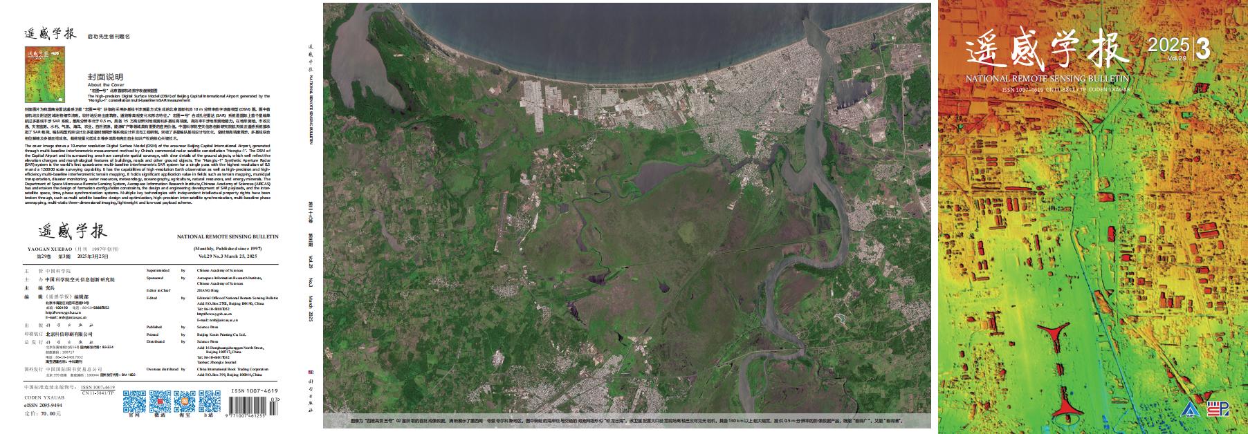
“宏图一号”北京首都机场数字表面模型图
封面图片为我国商业雷达遥感卫星“宏图一号”获取的采用多基线干涉测量方式生成的北京首都机场10 m分辨率数字表面模型(DSM)图。图中首都机场及附近区域地物细节清晰,较好地反映出建筑物、道路等高程变化和形态特征。”宏图一号”合成孔径雷达(SAR)系统是国际上首个星载单航过多基线干涉 SAR 系统,最高分辨率优于 0.5 m,具备 1:5 万高分辨对地观测和多基线高精度、高效率干涉地形测绘能力,在地形测绘、市政交通、灾害监测、水利、气象、海洋、农业、自然资源、能源矿产等领域具有重要的应用价值。中国科学院空天信息创新研究院航天微波遥感系统部承担了 SAR 载荷、编队构型约束设计及多星空时频同步等系统设计开发与工程研制,突破了多星编队基线设计与优化、空时频高精度同步、多基线联合相位解缠及多基三维成像、载荷轻量化低成本等多项具有完全自主知识产权的核心关键技术。
The high-precision Digital Surface Model (DSM) of Beijing Capital International Airport generated by the "Hongtu-1" constellation multi-baseline InSAR measurement
The cover image shows a 10-meter resolution Digital Surface Model (DSM) of the area near Beijing Capital International Airport, generated through multi-baseline interferometric measurement method by China's commercial radar satellite constellation "Hongtu-1". The DSM of the Capital Airport and its surrounding area have complete spatial coverage, with clear details of the ground objects, which well reflect the elevation changes and morphological features of buildings, roads and other ground objects. The “Hongtu-1” Synthetic Aperture Radar (SAR) system is the world's first spaceborne multi-baseline interferometric SAR system for a single pass with the highest resolution of 0.5 m and a 1:50000 scale surveying capability. It has the capabilities of high-resolution Earth observation as well as high-precision and high-efficiency multi-baseline interferometric terrain mapping. It holds significant application value in fields such as terrain mapping, municipal transportation, disaster monitoring, water resources, meteorology, oceanography, agriculture, natural resources, and energy minerals. The Department of Space Microwave Remote Sensing System, Aerospace Information Research Institute, Chinese Academy of Sciences (AIRCAS) has undertaken the design of formation configuration constraints, the design and engineering development of SAR payloads, and the inter-satellite space, time, phase synchronization systems. Multiple key technologies with independent intellectual property rights have been broken through, such as multi satellite baseline design and optimization, high-precision inter-satellite synchronization, multi-baseline phase unwrapping, multi-static three-dimensional imaging, lightweight and low-cost payload scheme.


