
水文循环的雷达遥感观测
Theme Keywords: radar remote sensingweather radarurban waterloggingsynthetic aperture radarremote sensingrainfall-runoff forecastingrainfallrain cells detection
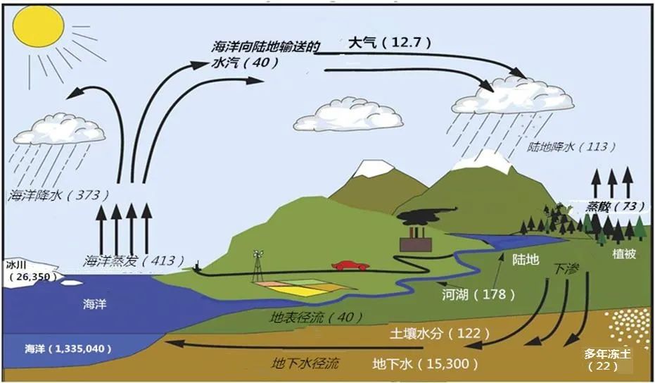
水文循环是地球上最重要的物质循环之一,对于地球表层结构的演变和人类可持续发展具有重大意义。自20世纪50年代中期降雨雷达的出现,面向水文循环的雷达遥感观测技术已历经60余年的发展,成为水文循环观测与认知的重要支撑。随着以相控阵、合成孔径、超视距、太赫兹为代表的雷达遥感技术的发展,大量雷达遥感数据被广泛用来反演时空上复杂多变的陆地水循环变量,推动着遥感科学与水文科学的发展。小编特向您推荐“水文循环的雷达遥感观测 ”专栏。
- The Paper
- Abstract:Rainfall is a key link in the earth’s water cycle and one of the most important inputs to hydrological and land surface models. Thus far, radar-based rainfall information has been widely used in global surface hydrology process simulation, disastrous weather forecast, flood control, and disaster relief because it provides data with a high spatial and temporal resolution that improves rainfall representation. In recent years, precipitation radar has gradually developed in a multiangle, multifrequency, dual-polarization, multiresolution, and multiantenna direction under different meteorological observation requirements and rainfall application scenarios. The radar observes rainfall in the air. Meteorological and hydrological research have different requirements for rainfall observation on the temporal and spatial scales. Thus, a series of conversion processes from radar rainfall observation in the air to the land surface generates considerable uncertainties. Thus, the accuracy of radar precipitation must be improved by systematic deviation corrections and data processing.In this study, a comprehensive review of the process of radar rainfall inversion aims to provide a general picture of the current state of multimode radar technology. First, the development characteristics of multimode radar remote sensing technology were summarized. Afterward, the basic process of converting aerial rainfall observed by radar to the surface of the land surface was sorted out. Furthermore, we reviewed and summarized the major progress and methods of precipitation radar rainfall inversion. The upscaling and downscaling applications in hydrological and land surface models were compared in the literature review. Then, we analyzed the factors causing the air-land surface rainfall deviation in the radar, such as raindrop evaporation, drift, and fragmentation. The calculation method of raindrop evolution deviation was also summarized. Moreover, we summarized the current methods for correcting radar rainfall based on ground-based reference rainfall, such as the rainfall observed by rain gauges. Finally, on the basis of this review, we discussed the existing major challenges and prospects in multimode radar precipitation, including developing multiscale inversion of surface rainfall, multimodel surface rainfall data fusion, surface rainfall inversion considering microphysical deviation of raindrops, and multimode radar data mining based on machine learning.Keywords:weather radar;radar precipitation estimation;radar remote sensing;multi-mode;urban waterlogging1133|4514|5
 <HTML><L-PDF><Enhanced-PDF><Meta-XML>Updated:2023-09-28
 - Abstract:The frequency of extreme rainfall and flooding in North China has increased because of the influence of climate change and human activities. Convective and strong precipitation processes occur in summer. Under the influence of the mixed flow generation mechanism in semihumid and semiarid areas, the flood burst is strong and difficult to forecast. Based on the Weather Research Forecast (WRF) model, namely, coupled WRF-Hydro, this study uses three-dimensional variational data assimilation (3DVAR) in constructing the WRF-3DVAR assimilation system for a rapid hourly update to assimilate high spatial and temporal resolution radar reflectivity data with the traditional meteorological observed data from the Global Telecommunication System (GTS). The study of rainfall-runoff prediction based on the land-atmosphere coupling is conducted by taking the typical rainfall processes of the north and south branches of the Daqinghe River Basin as the research object. Moreover, the performance of the rainfall-runoff prediction method in North China is further verified. The research results have some theoretical and practical values for constructing the data assimilation system of the atmospheric model and flood forecast practice in northern China.We employ three nested domains and adopt the GFS data for driving the WRF model. This study evaluates the improvement effect of WRF on forecasting rainfall and WRF-Hydro forecasting runoff by assimilating radar reflectivity and GTS data. The GTS data are released every 6 h. Thus, in the hourly assimilation scheme, GTS is only assimilated at the 6th, 12th, 18th, and 24th h from the start of the storm. However, radar reflectivity is set to assimilate once every hour. The rainfall evaluation indexes include Root Mean Square Error (RMSE), Mean Bias Error (MBE), and Critical Success Index (CSI). CSI/RMSE is a comprehensive index for evaluating rainfall forecast results. RMSE, MBE, and Nash (Nash-Sutcliffe efficiency coefficient) are used to evaluate runoff.The results show that the precipitation forecasted by the WRF model is always lower than the observed rainfall. However, assimilation systems can increase rainfall. The improved initial conditions in the WRF-3DVAR system via radar data assimilation and GTS data achieve good short-term and convectively strong precipitation. The high assimilation frequency significantly helps trigger and maintain the convective activities in the 3DVAR framework and the storm case applied. The assimilation weather radar combined with the traditional meteorological observed data can effectively improve the rainfall prediction accuracy of the WRF model, particularly for the rainfall with uniform spatial and temporal distribution. The CSI/RMSE index of the forecast rainfall after assimilation is increased by 23.24%—50.00%. Whether data assimilation is carried out or not, the CSI index results show different degrees of rainfall false alarm frequency. In the runoff forecast, the accurate rainfall forecast after data assimilation also improves the runoff forecast results to a certain extent. The peak flow error is reduced by 15.05%, 38.07%, 18.53% and 6.99%, the flood volume error is reduced by 25.99%, 29.32%, 26.02% and 23.95%, and the Nash efficiency coefficient is increased by 0.25, 0.25, 0.29 and 0.48, respectively. However, the forecast results of flood peak discharge and the peak occurrence time for the rainfall with uneven spatial and temporal distribution, large magnitude, and slow water retreat are still not ideal. Moreover, subsequent improvements should be made in terms of accurate calibration of hydrological parameters and real-time correction of forecast errors. The accuracy of the WRF-Hydro runoff forecast in the mixed runoff generation areas of northern China mainly depends on two aspects. One is the accuracy of the rainfall forecast of WRF model, which is related to the driving data and rainfall distribution type. For the rainfall with uneven spatial-temporal distribution, the poor rainfall forecast indirectly affects the runoff forecast effect. On the contrary, it is related to different runoff characteristics, such as the complexity of the runoff process, the magnitude of runoff, the presence or absence of base flow in the early stage, and the soil water content. Data assimilation improves rainfall forecast. Thus, the runoff forecast results of WRF-Hydro are improved to a certain extent by reasonably using a basic flow module, improving land surface initial conditions, such as soil water content, and combining with effective real-time correction technology.Keywords:remote sensing;data assimilation;Doppler Weather Radar;quick cycle update;WRF-Hydro;rainfall-runoff forecasting1666|3744|3<HTML><L-PDF><Enhanced-PDF><Meta-XML>Updated:2023-09-28
- Abstract:Ocean rainfall has an important impact on the global atmospheric cycle and local climate. Monitoring rain cells from remote sensing images is vital for ocean weather prediction. The ability of Synthetic Aperture Radar (SAR) to probe with a wide swath and high spatial resolution makes it an effective observation approach for rain cells with a scale of 10—30 km. This study uses the fusion-feature-based Broad Learning System (BLS) to detect the rain cells. The SAR images dataset composed of nine sea surface phenomena obtained by Sentinel-1 wave mode is also used. Results show that the detection accuracy is 98.51%, and the recall rate is 95.24%. These values are equivalent to those of the ResNet50 pretrained model. However, the training time of ResNet50 is 20 times that of BLS under the same calculation conditions. Compared with the structure of a deep learning network, that of BLS is flexible. That is, the model can be optimized and updated by adding nodes or input data. The experiments show that the node incremental learning of BLS can update the model without retraining the whole model. Following the advantages of the incremental learning and retraining schemes, this study proposed a hybrid model-updating scheme for the model-updating task caused by the expansion of the training dataset. This new scheme can ensure the high accuracy of the model and significantly reduce the time cost for model updating.Keywords:Artificial intelligence detection;rain cells detection;broad learning system;synthetic aperture radar;model updating1139|2176|2<HTML><L-PDF><Enhanced-PDF><Meta-XML>Updated:2023-09-28
- Abstract:The raindrop size distribution (DSD) is used to describe the distribution of raindrop diameters during the rainfall process, which can effectively reflect the microphysical characteristics of raindrops. DSD-derived empirical relationships, including radar reflectivity factor-rainfall intensity (Z-R) and unit rainfall kinetic energy-rainfall intensity (KE-R), are key factors in research fields such as radar quantitative precipitation estimation and soil erosion assessment. At present, the ground disdrometer is generally used to obtain DSD directly at a given site, which is difficult to represent the spatial difference of the large-scale raindrop microphysical process. The dual-frequency precipitation radar (DPR) carried by the global precipitation measurement mission (GPM) core satellite can receive radar echoes of two different bands to obtain more raindrop information, which makes it possible to retrieve spatial three-dimensional DSD parameters. Based on the DSD surface estimations, including the mass weighted mean drop diameter (Dm) and normalised intercept parameter (Nw) of GPM-DRP in its 2ADPR product during the entire 4 years (2017—2020), this study calculated rainfall intensity, unit rainfall kinetic energy, radar reflectivity factor and other parameters of each record, constructed the empirical relationships between Z-R and KE-R in grid scale, and used the observation DSD data of 11 disdrometer stations in the Yangtze River Delta region as a reference to verify and evaluate the reliability of GPM-DPR to estimate DSD parameters and fit microphysical empirical formulas, which is useful for improving the accuracy of large-scale radar rainfall estimation and soil protection decision-making. The results showed that by comparing the DSD estimation of disdrometers and GPM-DPR, it can be found that under the same rainfall intensity class, DPR-derived Dm at most sites is slightly larger than the measured result of the disdrometer at the same location, while DPR-derived Nw is higher than that of the disdrometer. As for rainfall types, the raindrops of disdrometer are mostly stratiform rain, and only a small part is high-intensity convective rain. However, due to radar sensitivity limitation, the DPR-detected raindrops are almost completely distributed in the stratiform. For the empirical formula fitted by rainfall characteristics, the KEs derived from DPR are mainly distributed on both sides of the KE-R empirical formula by corresponding disdromters. In addition, Pearson coefficient of most stations can reach more than 0.60, and at Nantong, Jiaxing and other sites, it even exceed 0.70, which proves that DPR is suitable for inferring the empirical relationship between KE and R. It means that DPR has the ability to infer those rainfall microphysical relationships in place of disdrometers in areas where site data is scarce. What is more, the DPR results perform best when it exceeds 0.5 mm h-1, with small errors and high correlations. Overall, DPR remote sensing has good DSD inversion performance, which is expected to provide new support for large-scale radar quantitative precipitation estimation and soil retention decision-making. However, due to the characteristics of orbital scanning by spaceborne radar, DPR cannot make continuous observations of rainfall events in the same area, which makes it detect a low amount of data in a limited orbital range and limits its application ability to detect rainfall events. On one hand, in order to achieve a more accurate estimation of the rainfall microphysical characteristics, it is necessary to obtain DPR data with a longer duration. On the other hand, the DPR data can be used as a correction tool to be integrated with numerical weath.Keywords:rainfall;Disdrometer;radar remote sensing;GPM;Rainfall Kinetic Energy1427|3126|0<HTML><L-PDF><Enhanced-PDF><Meta-XML>Updated:2023-09-28


